Detecting Landslides and Mine Subsidence
Slow ground movement is when the ground moves small amounts over a period of days, weeks, or months rather than something that happens more rapidly over minutes. It is difficult to notice slow ground movements because they occur so slowly. We are using satellite data to detect and monitor slow ground movements as small as a few millimetres. Our work focuses on ground movement associated with landslides, abandoned coal mines, oil sands mines, and oil and gas activities.
More About Slow Ground Movement Detection
To detect slow ground movement, we analyze a large image stack of synthetic aperture radar (SAR) images acquired by a satellite every 12 days over the same area. Interferometric SAR (InSAR) measures displacement on Earth’s terrain using two SAR observations of the same area with slightly different sensor positions. Satellite InSAR measures ground deformation in the east-west direction along the line of sight, which is a straight line between the SAR antenna and Earth’s terrain. The line of sight and viewing geometry of the satellite limits the magnitude and direction of ground movement that is detectable. The millimetre-scale measurements are more reliable when taken on bare surfaces and areas with less vegetation cover. We can increase the reliability of measurements in vegetated areas by installing corner reflectors. These reflectors are constructed of three metal plates and reflect stronger radar signals back to the satellite improving its detection of slope movement, particularly slow-moving landslides in heavily vegetated areas. Although reflectors can enhance detection, installing and maintaining them is costly and therefore they are used only in special circumstances.
Learn More About
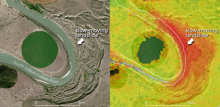
Our experts use two tools for identifying landslides in Alberta, our published landslide susceptibility model and satellite InSAR data. Our landslide susceptibility model predicts landslide-prone areas in the province and displays them on a map. We use InSAR data for identifying active slow-moving landslides. Some of these active slow-moving landslides could pose risks to infrastructure and public safety.
Learn More About
Relative Landslide Susceptibility Model of the Alberta Plains and Shield Regions, Version 2
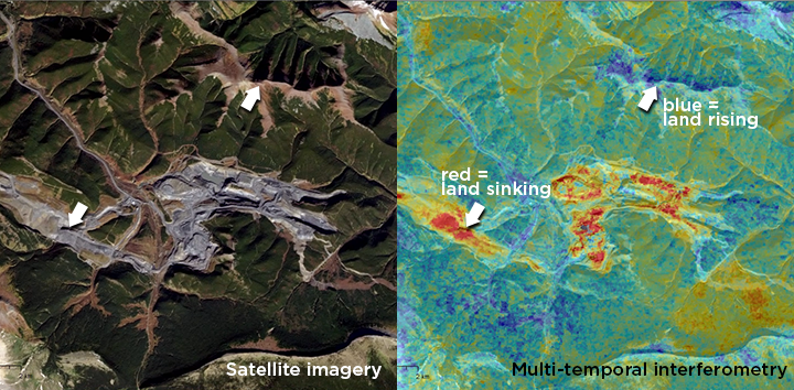
Abandoned mines are often the sites of ground movement with cracks forming and/or ground subsiding; this could cause environmental hazards and pose risks to public safety. Analysis of satellite interferometric SAR (InSAR) data allows us to detect slow-moving deformation over mines. For example, we detected active subsidence over an abandoned coal mine in west-central Alberta using November 2020–November 2021 Sentinel-1 satellite data.
The Athabasca Oil Sands area in northeastern Alberta contains one of the world’s largest deposits of bitumen. These deposits lie near the surface making open-pit mining possible. Analysis of satellite interferometric SAR (InSAR) data reveals ground movement over open-pit mines, dams, and tailings ponds and helps to verify site compliance status for safe and environmentally responsible development. We detected both surface heave and subsidence over an area of the Athabasca Oil Sands from 2017–2020 Sentinel-1 satellite data.