Groundwater Availability Based on Hydrologic Data
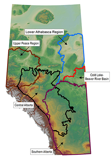
Groundwater availability is the amount of water in the groundwater system. Groundwater availability estimates are based on hydrologic data and presented at a watershed scale for non-saline resources. We adapted an approach to mapping groundwater availability based on the aquifer yield continuum concept created by Pierce et al. in 2013. This approach provides regional first-order assessments of groundwater availability in Alberta. Using the aquifer yield concept, we calculate groundwater yield within 150 m below the ground surface along a spectrum of total groundwater availability. The spectrum is bound by two extremes: nonuse and maximum mining – where nonuse represents no water withdrawn from the groundwater system and maximum mining represents all the water withdrawn from the groundwater system. To date, we have mapped central Alberta, southern Alberta, the upper Peace region, the lower Athabasca region, and the Cold Lake-Beaver River Basin.

More About Groundwater Availability
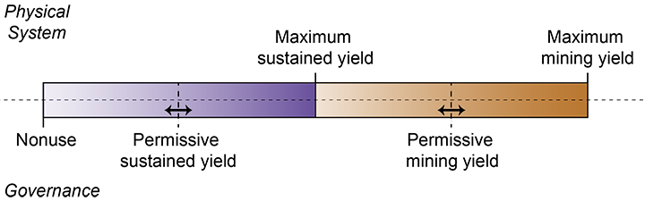
The aquifer yield continuum concept depends on hydrogeological parameters such as recharge, discharge, and water volume. The method for quantifying each parameter may vary depending on scale, data availability, hydrogeological regime, climate, and landscape characteristics of the study area. This continuum can be divided into five classes: nonuse, permissive sustained yield, maximum sustained yield, permissive mining yield, and maximum mining yield as illustrated below. The permissive sustained yield falls along the continuum at some point between nonuse and maximum sustained yield. Our groundwater availability mapping focuses primarily on the maximum sustained yield, which is equivalent to the natural rate of recharge. It is the maximum amount of groundwater that is available in the hydrogeological system without mining groundwater (i.e., taking more water from the aquifer than can be naturally replenished).
We applied the aquifer yield continuum approach to five areas of the province. We used different methods to estimate recharge because of differences in data availability and landscape characteristics for each area. The methods used for each area are as follows:
- In central Alberta, groundwater discharge to rivers (baseflow) was used to estimate recharge.
- In southern Alberta, where depression-focused recharge is a dominant recharge mechanism in the Canadian Prairies, a one-dimensional recharge modelling approach was used to estimate recharge.
- In the upper Peace region, both baseflow and one-dimensional recharge modelling approaches were used to estimate recharge.
- In the lower Athabasca region, groundwater flow models were used to estimate recharge.
- For the Cold Lake-Beaver River Basin, groundwater flow models were used to estimate recharge.
For each area, we aggregated the recharge estimates and took the spatial average (in mm/yr), for each of the Hydrologic Unit Code 8 (HUC8) watersheds; we then multiplied by the area of the watershed to determine the maximum sustained yield (m3/yr) for each area. We now have groundwater availability estimates for 240 HUC8 watersheds in Alberta.
Access our groundwater availability estimates:
Central Alberta
- Open File Report 2017-07 - First-Order Groundwater Availability Assessment for Central Alberta
- Digital Data 2017-0024 - Groundwater Yield Matrix for Central Alberta (GIS data, polygon features)
Southern Alberta
- Open File Report 2018-09 - First-Order Groundwater Availability Assessment for Southern Alberta
- Digital Data 2018-0011 - Groundwater Yield Continuum for Southern Alberta (GIS data, polygon features)
Upper Peace Region
- Open File Report 2019-10 - First-Order Groundwater Availability Assessment for the Upper Peace Region
- Digital Data 2019-0016 - Groundwater Yield Continuum for the Upper Peace Region (GIS data, polygon features)
Lower Athabasca Region
- Open File Report 2020-05 - First-Order Groundwater Availability Assessment for the Lower Athabasca Region
- Digital Data 2020-0032 - Groundwater Yield Continuum for the Lower Athabasca Region (GIS data, polygon features)
Cold Lake Beaver River Basin
- Digital Data 2021-0010 - Groundwater Yield Continuum for the Cold Lake-Beaver River Basin (GIS data, polygon features)
- There is no open file report for this region.
For more information on Hydrologic Unit Code 8 (HUC8) watersheds, see the Government of Alberta’s dataset Hydrologic Unit Code Watersheds of Alberta, located on the Geodiscover Alberta website.
The aquifer yield continuum is one approach for estimating groundwater yield in Alberta. It is easily modified by using different methods to quantify the hydrogeological parameters (recharge, discharge, water volume), making this approach useful throughout the province because the data available can vary from area to area. The groundwater availability results at the HUC8 watershed level can be used as a screening or risk assessment tool to identify watersheds of interest (e.g., overused watersheds) after which further groundwater assessments could be conducted considering local knowledge and specific scenarios.