Tracking the Return of Vegetation at Oil, Gas, and Mine Sites
After oil and gas, and mining companies stop activities at their sites, they must restore those sites back to the state the land was in before they started working there; this is called site reclamation. We monitor reclamation performance at those sites by analyzing satellite imagery for vegetation recovery trends. To assess these changes, we classify land cover into 11 classes, such as mixed forest, wetland, and exposed/barren land. Site reclamation is required and monitoring this process helps the Alberta Energy Regulator determine if companies comply the regulations and when they can receive the certificate for successfully reclaiming a site.
More About Monitoring Site Reclamation
We use imagery from Landsat-4 to -8, Sentinel-2, and SPOT 6/7 satellites for reclamation monitoring. Satellites, such as Landsat, have collected imagery since the 1980s, providing valuable information on land changes through time. For vegetation trend analysis, we use red, near-infrared (NIR), and shortwave infrared (SWIR) spectral bands in multitemporal images (these are images of the same area acquired at different times) to assess biomass content, vegetation health, canopy density, and leaf moisture content. When evaluating vegetation loss and regeneration at a reclamation site, we look at cloud-free mid-summer imagery from Landsat (1985 to present) and Sentinel-2 (2017 to present) satellites over multiple years.
At a typical oil and gas well lease site, the developer clears vegetation from a 100 m by 100 m area and a narrow access road. When assessing a site, we apply a 150 m buffer zone around the clearing and access road to create a control site boundary. We visually assess vegetation regeneration based on matching the land-cover types inside the well lease site with ones in the control site or surrounding undisturbed area. This shows us if the site is reverting to its natural state, with the same vegetation growing in the undisturbed area. The reclamation process may take many years or even decades depending on severity of soil disturbance and land-cover types (for example, forest, native grassland, and peatland are slow to regenerate). Lease sites with undisturbed topsoil usually show rapid vegetation regeneration compared to sites where they replaced topsoil with new organic topsoil during the reclamation process.
Learn More
Time-Series Multispectral Data and Google Earth Engine For Reclamation Assessment in Alberta
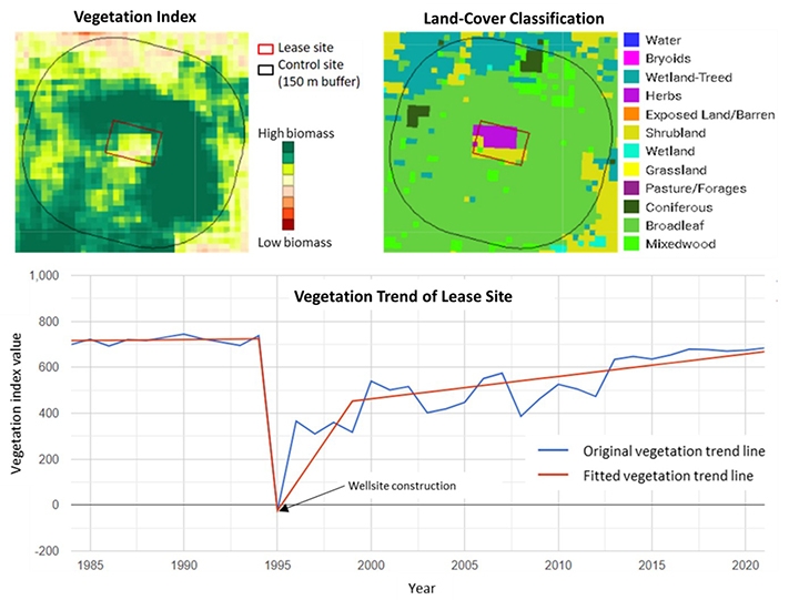
Image: Copernicus Sentinel data 2021
Unlike a small oil/gas well lease site, an area leased for surface and underground coal mining could be several tens of square kilometres, however, mining activities do not impact the whole lease site. The reclamation auditing process for a surface coal mine lease site consists of identifying areas of disturbed or removed vegetation to assess the ground and track the reclamation progress. We create change-detection maps for tracking vegetation type and health before, during, and after mining activities to highlight vegetation loss, disturbance, and regeneration. In addition, we produce a current-state land-use/land-cover classification map to quantify areas of regenerated vegetation by type and the area of the remaining footprint of the mine.
Maps and charts of the coal mining reclamation process help the Alberta Energy Regulator assess and quantify disturbances and vegetation recovery in a chronological sequence. This information is crucial to determining whether a reclamation certificate can be granted.
Learn More
Coal Mine Reclamation Performance Assessment using Time-Series Landsat Data