Finding Mineral Resources in Alberta
Detecting minerals on hyperspectral or multispectral satellite imagery is possible because minerals have distinct spectral absorption features that affect their appearance on satellite images. Using multispectral imagery, we have successfully tested mineral detection techniques on multiple regions of Alberta. As of 2022, we are using commercial imagery to find surface exposures, or outcrops, of alteration minerals like uranium and rare-earth elements in northeastern Alberta and for finding iron-bearing outcrops in northwestern Alberta.
More About Mineral Resources
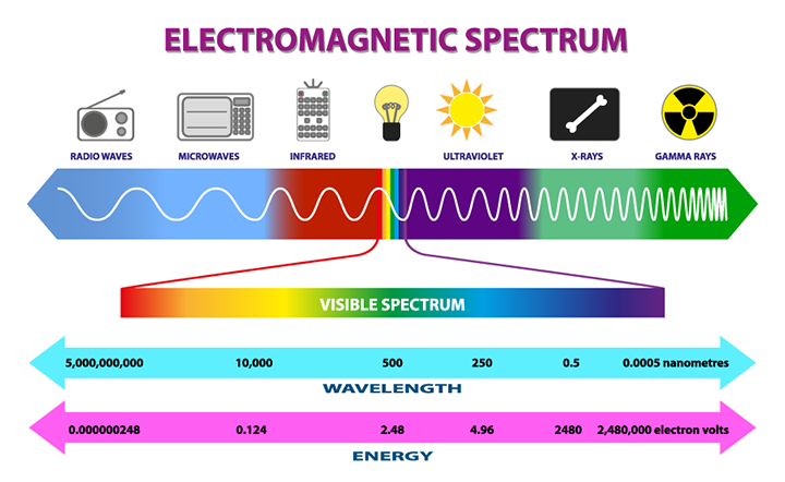
Multispectral and hyperspectral satellite imagery is the product of a satellite collecting electromagnetic wavelength data from the Earth’s surface and displaying it in the form of an image. The electromagnetic spectrum is the range of light waves that includes
- radio waves,
- microwaves,
- infrared,
- visible,
- ultraviolet,
- x-rays, and
- gamma rays.
Within these spectra there are bands of light. Multispectral imagery uses between 3 and 10 bands of visible and infrared light, whereas hyperspectral imagery uses hundreds of bands.
Everything emits electromagnetic light energy as waves at different lengths we can identify. This helps us identify what the object is and what it is made of. In addition to light naturally emitted, minerals also have distinct light absorption features that affect how they appear on spectral imagery, making this a good technique for exploring for minerals close to Earth’s surface.
Commercial multispectral or hyperspectral imagery has higher spatial resolution than spaceborne multispectral imagery, meaning that it detects wavelengths from patches of Earth’s surface ranging from 0.5–4 m, whereas the spaceborne multispectral imagery resolution ranges from 10–30 m. The improved resolution from the commercial imagery provides more detailed mineral absorption features, including information captured by the more visible and near-infrared and short-wave infrared bands, covering the 0.4–2.5 micrometres wavelength range.
Spectral mixture analysis is estimating the proportion of a targeted material throughout an image. Through spectral mixture analysis of Sentinel-2 multispectral satellite imagery, we delineated bedrock outcrops containing iron occurrences on the east bend of Peace River, west of the Town of Fairview, northwestern Alberta. There are 0.3 to 3 m thick outcrops of sandstone at different locations along a 24 km stretch of the river. This oolitic sandstone is within the Upper Cretaceous Dunvegan Formation and hosts these iron occurrences. Continued use of this and other similar techniques for detecting and delineating surface occurrences of metallic minerals will help exploration efforts in our province.
![]()
Image: Copernicus Sentinel data 2019