Chapter 8 - Middle Cambrian to Lower Ordovician Strata |
|
| Chapter Sections | Download |
|
|
Introduction
Overview
This chapter deals with Middle Cambrian, Upper Cambrian and Lower Ordovician rocks (Sauk II and III sequences of Sloss, 1963) of the Western Canada Sedimentary Basin (WCSB).
The interval is particularly well exposed in the front and main ranges of the Southern Rocky Mountains, where alternating units of carbonates and siliciclastics attain thicknesses greater than 3500 m. The mountain sections are generally underlain by Lower Cambrian clastics and overlain by Middle Ordovician and Middle Devonian limestones and clastics, and carbonates of Late Devonian age.
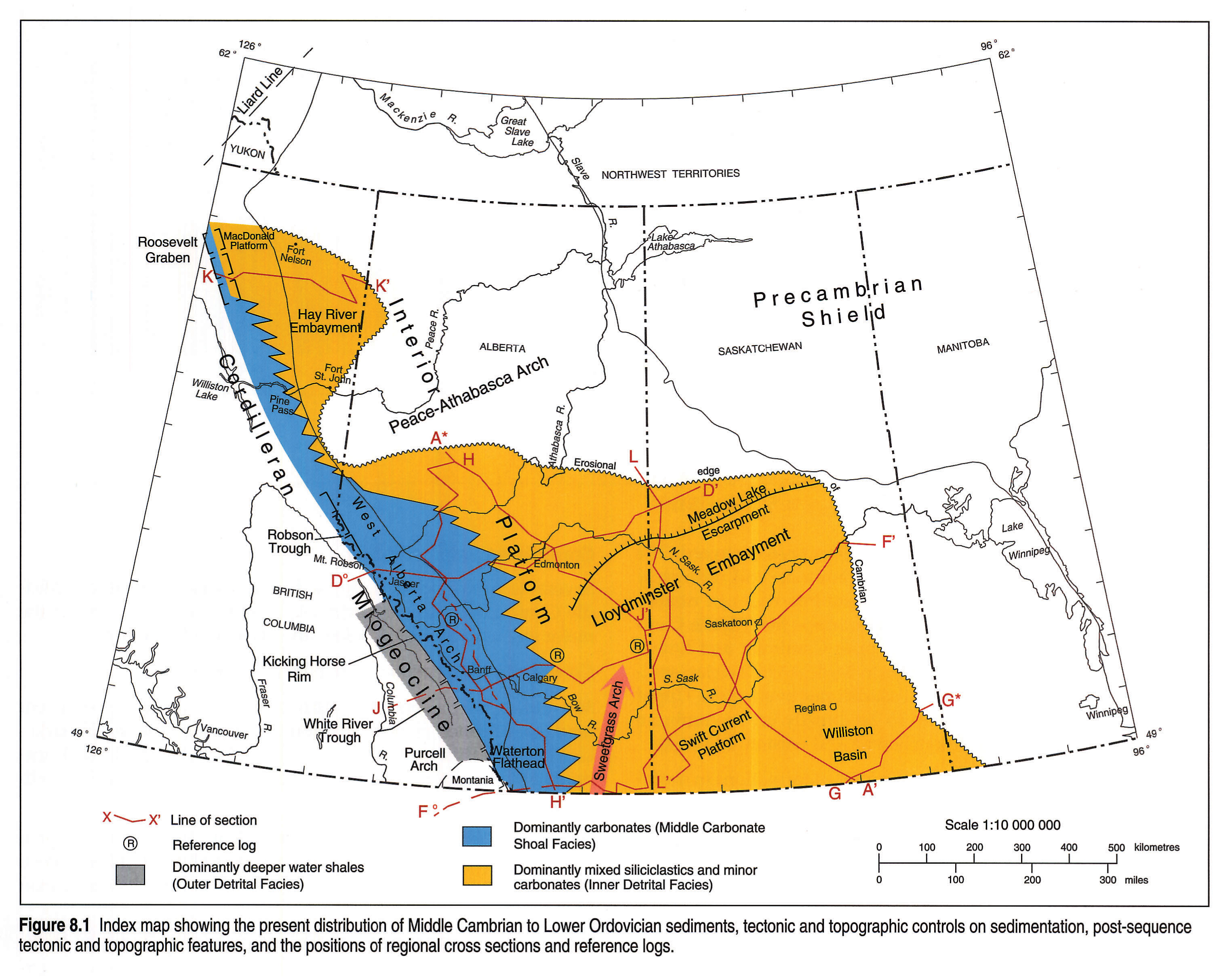
The interval is widely developed in the subsurface of the foothills and plains as far north as about 54°N latitude in Alberta and Saskatchewan, and extends into southwestern Manitoba (Fig. 8.1). The sediments in the plains are dominantly siliciclastic and lie unconformably on crystalline Precambrian rocks of the Canadian Shield. The sequence locally reaches thicknesses of more than 500 m in the subsurface but is deeply eroded at the sub-Devonian unconformity in central and northern Alberta and in northern Saskatchewan. The sequence pinches out in eastern Saskatchewan below overstepping Middle Ordovician strata.
A small remnant of strata, interpreted as Middle Cambrian, occurs in the Hay River Embayment, north of the Peace-Athabasca Arch. These strata are probably contiguous with the Cambrian and Ordovician sections of northeastern British Columbia. However, some believe that these rocks are of Middle and Early Devonian age.
The present synthesis describes the general lithology and distribution of Cambrian and Lower Ordovician strata in the subsurface of the Western Canada Sedimentary Basin, and correlates these strata with coeval formations in the Rocky Mountains.
The main original contributions of this chapter lie in the eight regional cross sections that pass through the basin (Figs. 8.8 left pane, 8.8 right pane, 8.9, 8.10, 8.11 left pane, 8.11 right pane, 8.12, 8.13, 8.14, 8.15) and the four regional maps (Figs. 8.19, 8.20, 8.21, and 8.22). The remaining material draws heavily from the published and private writings of many scientists, here extensively abstracted and paraphrased. Particular reliance is placed on the excellent work of J.D. Aitken for information on the Cambrian in the mountains and on the subsurface work of H. van Hees and D.C. Pugh. Lower Paleozoic rocks north and west of the Hay River Embayment, or in the areas west of the Main Ranges are not dealt with here. Interested readers are directed to Aitken (in press b) and North (1964).
Previous Work
Early work on the Cambrian and Lower Ordovician was first conducted in the Southern Rocky Mountains. Charles D. Walcott, the eminent Cambrian paleontologist, conducted research in the area from 1907 to 1925 and his posthumously published paper (1928) summarized much of his work. It provides a guide to his earlier publications. J.A. Allen mapped in the Bow Valley to the Golden area from 1911 to 1915 (Allan, 1914a,b). L.D. Burling worked on the Cambrian from 1914 to 1923 (Burling, 1914) and later presented a summary of Cambrian studies (Burling, 1955). Charles Deiss' stratigraphic studies were conducted in the late 1930s (Deiss, 1940).
Modern work began with Rasetti (1951, 1956). Aitken began his major studies on the Cambrian in 1961 and continued until 1991 (Aitken, 1966, 1968, 1971, 1978, 1981, 1989a,b, in press a,b). Other important works include Ney (1954), Mountjoy (1962), North (1964), Mountjoy and Aitken (1978), Norris and Price (1966), Slind and Perkins (1966), Aitken and Greggs (1967), Aitken and Norford (1967), Norford (1969, 1990), Cook (1975), McIlreath (1977), Taylor (1981), Stewart (1991) and Dean (1990). H.B. Whittington, S. Conway Morris and others have published and continue to work on the exquisite and unique faunas from the Burgess Shale (Whittington, 1980, 1985; Conway Morris and Whittington, 1985). D.H. Collins (see Pringle, 1989) is renowned for finding new "soft-bodied" occurrences other than at the original locality. W.H. Fritz made important paleontological and stratigraphic contributions to Cambrian geology of the Southern and Northern Rocky Mountains (Fritz, 1972, 1978, 1979, 1980; Fritz and Mountjoy, 1975, Aitken et al. 1972). Major studies of the Cambrian in Western United States have been published by Palmer (1960) and Robison (1960).
Hendrik van Hees (1959, 1964) published regional syntheses of the subsurface Cambrian. Since then, major studies of the subsurface Cambrian were conducted by Pugh (1971, 1973, 1975) and by Tawadros (1988).
Cambrian faunas in the subsurface of Alberta were studied by Raasch and Campeau (1957) and Hutchinson (1960).
Considerable work has been done in Saskatchewan and in other parts of the Williston Basin. These works include those of Carlson (1960), Fyson (1961), Hutt (1963a,b), Fuller and Porter (1962), Paterson (1988, 1989), and Lefever et al. (1987).
Economic Geology
Middle Cambrian to Lower Ordovician rocks do not produce hydrocarbons in the Western Canada Sedimentary Basin, although a few gas shows have been encountered and some minor oil staining has been recorded (van Hees, 1959; Pugh, 1971).
Middle Cambrian Eldon carbonates have been mined for lime near the mountain front along the Bow River, and lead and zinc deposits in the Kicking Horse Pass have been commercially developed (Ney 1954). Helium and nitrogen have been produced in southwestern Saskatchewan from Upper Cambrian dolomite sands on or near their contact with the underlying Precambrian (van Hees, 1964; Thompson, 1967).
Geological Framework
Overview
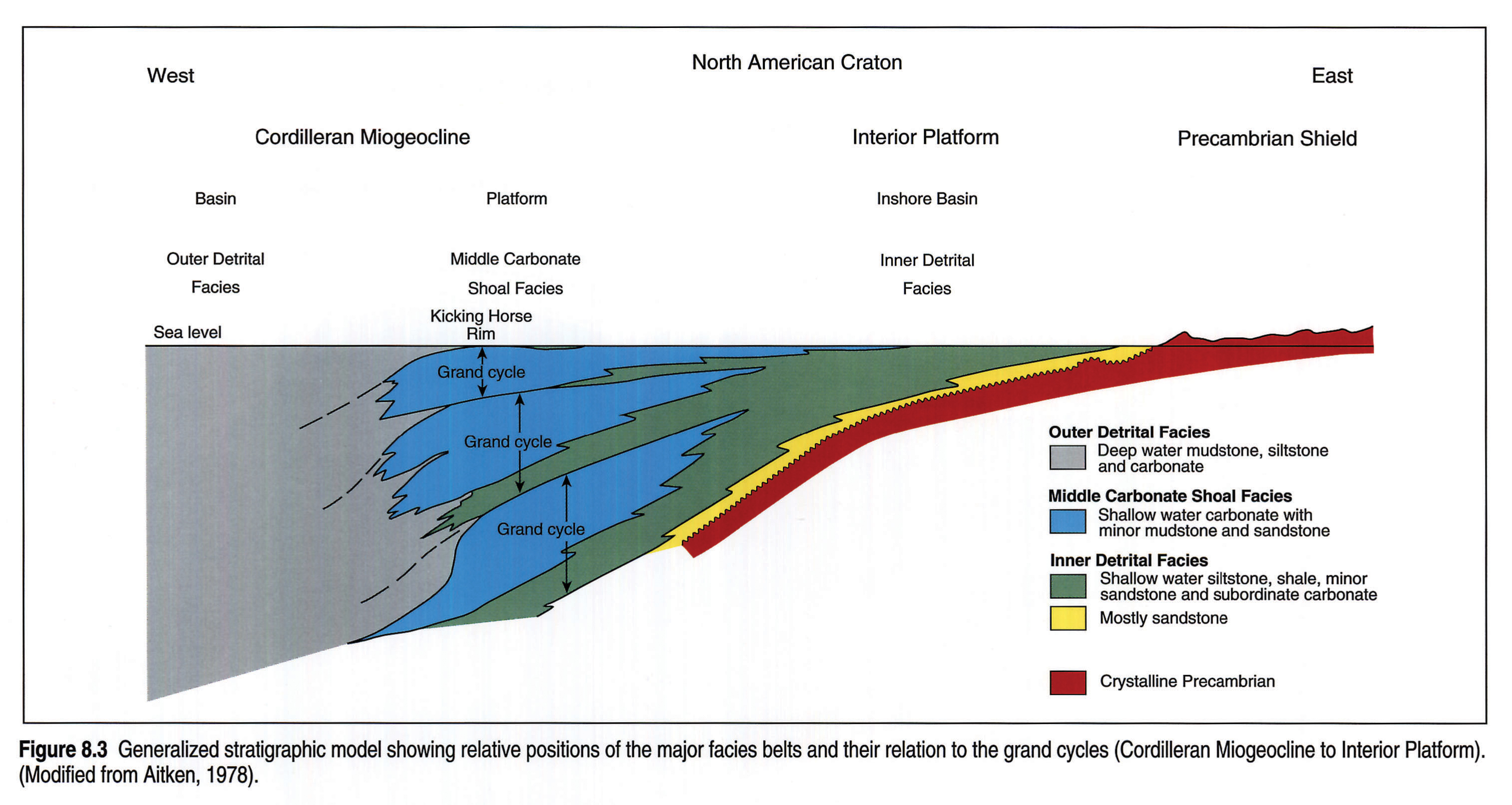
Cambrian to Lower Ordovician sediments were deposited on the Interior Platform of the North American craton and in the bordering Cordilleran Miogeocline (Cordilleran Trough)(Fig. 8.3).
The Cordilleran Miogeocline was a major depositional region intermittently active from late Precambrian to Triassic time. The Cordilleran rocks were deposited on a passive margin and form a westward-expanding, thick wedge of carbonate and clastic sediments with minor volcanic rocks (Aitken, 1989b). Basinal clastics dominate to the west and platform sequences of shallow-water carbonates and minor clastics are predominant to the east.
The Interior Platform sediments are of similar age to the miogeocline rocks but are much thinner and contain internal unconformities and disconformities. The sediments were deposited on a stable, Precambrian crystalline basement and thin from the base by depositional onlap, internally by diminution and internal unconformities, and from the top by erosion.
Cambrian and Lower Ordovician clastic deposits of both the miogeocline and platform came mainly from eroded Precambrian rocks of the Canadian Shield, and sedimentation was influenced by topographic and tectonic features. The maturity of quartz grains indicates a certain amount of reworking of earlier sediments. Transgression of the Cambrian seas was directed mainly eastward, but the ancestral Peace-Athabasca Arch was emergent for at least some of Middle Cambrian to Early Ordovician time and was responsible for the orientation of certain east-west-trending shorelines.
Stratigraphic History
Early Cambrian sedimentation was largely restricted to the miogeocline at the western margin of the craton. Sedimentation continued into the Middle Cambrian and with a rise in sea level and/or continued miogeoclinal subsidence, transgression progressed to the east and northeast.
In the west, sedimentation was relatively continuous, and a thick, cyclic sequence of carbonates and fine-grained clastics was deposited. To the east, coarse-grained clastics, derived from the Precambrian crystalline shield, formed at the shoreline of the advancing sea. These shoreline deposits are older in the west and progressively younger in the east (Pugh, 1971). The coarse-grained clastics are succeeded by shales, siltstones and fine glauconitic sandstones that show coarsening toward the contemporary shorelines in the east and north. The depositional surface was quite irregular and local Precambrian highs in southeastern Alberta and southwestern Saskatchewan were emergent through much of Middle Cambrian time.
Younger packages of sediment overlap older ones eastward. The Middle Cambrian overlaps the Lower Cambrian and ultimately lies unconformably on Precambrian crystalline rocks in eastern Alberta. The Upper Cambrian in turn overlaps the Middle Cambrian in central Saskatchewan. The Upper Cambrian and Lower Ordovician were partly eroded prior to Middle Ordovician sedimentation, and Middle Ordovician sandstones overlap the Upper Cambrian and Lower Ordovician to lie directly on Precambrian crystalline rocks in eastern Saskatchewan and western Manitoba.
The limits of the Middle and Upper Cambrian formations in northern Saskatchewan form part of the Meadow Lake Escarpment, which was created as an erosional feature during the Early Devonian. The formations show no signs of depositional thinning in this region, indicating that Middle to Late Cambrian shorelines were probably a good distance beyond their present northern edges.
Early Devonian erosion also removed a great deal of the Cambrian and Lower Ordovician in northern and western Alberta.
Controls on Sedimentation
Several tectonic and topographic features greatly influenced Middle Cambrian to Lower Ordovician sedimentation. A few of the major elements are listed below and shown in Figure 8.1.
Cordilleran Miogeocline - Cordilleran Trough
Montania (Norris and Price, 1966) - an early Paleozoic, persistent land mass formed of Belt-Purcell rocks situated near the Canada - U.S. border. This land mass was exposed during the Early Cambrian and was later covered by Middle Cambrian marine sediments.
Robson Trough (Young, 1979) - a trough in the Mt. Robson area that received an exceptional amount of sediment during Windermere deposition and through Cambrian and Early Ordovician time.
Kicking Horse Rim (Aitken, 1971) - a prominent feature within the eastern Cordilleran Miogeocline, situated along the western margin of the "middle carbonate shoal facies". The rim is a narrow, carbonate shoal that separated platform carbonates and shallow-water clastics to the east from deeper water clastics and minor carbonates of the "basinal facies" to the west. The rim was present from Middle Cambrian to Ordovician time and had a profound influence on sedimentation (McIlreath, 1977).
Roosevelt Graben - a depocenter situated in the Rocky Mountains north of the Peace-Athabasca Arch. It is variably thick and contains diverse lithofacies of Middle Cambrian sediments, probably as a result of horst-and-graben tectonics.
MacDonald Platform - a stable cratonic platform area east of the Roosevelt Graben.
White River Trough - a depocenter in southeastern British Columbia that started subsiding in the mid-Early Ordovician and continued throughout most of the Ordovician.
Interior Platform - the cratonic Interior Platform of the WCSB, dominated by two embayments separated by the Peace-Athabasca Arch.
Lloydminster Embayment (van Hees, 1964) - a broad depression developed on the Interior Platform during the Middle Cambrian in southern Alberta and Saskatchewan. This depression, or normal platform situated between "highs", lies between an uplift in central Montana to the south, the Canadian Shield to the east and the Peace-Athabasca Arch to the north. The embayment opens westward toward the Rocky Mountains.
Peace-Athabasca Arch - a positive area in northern Alberta, which affected Middle and Late Cambrian sedimentation. The arch forms the northern edge of the Lloydminster Embayment. It was deeply eroded by the sub-Devonian unconformity, but facies trends suggest that east-west shorelines bordered the arch in Middle Cambrian time. The Cambrian interval thins over the apparent western projection of the arch in the mountains of northeastern British Columbia (McMechan, 1990).
Hay River Embayment (van Hees, 1964) - a depositional area northwest of the Peace-Athabasca Arch, developed on the Interior Platform, containing remnants of rocks that have been interpreted as being equivalent to Lower and Middle Cambrian units of central Alberta. The rocks have not been dated, and some of the strata may be younger than here interpreted. The embayment extends westward into the mountains of northeastern British Columbia.
Liard Line (Aitken, in press b) - a linear tectonic element that extends from the southeast corner of the Yukon to the southeastern edge of Great Bear Lake. It is mainly a Precambrian structure that separates the Interior Platform of the south from the Selwyn Basin and other northern features.
Post-Lower Ordovician Influences
Several major tectonic and erosional features developed after the end of the Early Ordovician. These have had a profound influence on the present-day position and preservation of Middle Cambrian to Lower Ordovician strata.
The Cambrian and Lower Ordovician of the basin were subjected to two major periods of erosion, one prior to the Middle Ordovician and the other prior to the late Early Devonian. Evidence of the sub-Middle Ordovician unconformity is preserved beneath the Red River and Winnipeg formations in Saskatchewan and eastern Alberta. There seems to be little topographic relief on this unconformity. Intense erosion occurred at the sub-Devonian unconformity, the softer clastics offering little resistance after the protection of overlying lower Palaeozoic carbonates had been removed. In the plains, the Cambrian was completely eroded a short distance north of the Meadow Lake Escarpment and is missing in northern Saskatchewan and from most of northern Alberta, except for the Hay River Embayment (Fig. 8.1).
The Meadow Lake Escarpment is a striking pre-Devonian erosional feature that is present in central Saskatchewan and eastern Alberta (Fig. 8.1). The escarpment faces north and northwest and is composed of Cambrian and Lower Ordovician clastics capped with Upper Ordovician carbonates. Immediately north of the escarpment rim, up to 500 m of Cambrian and Ordovician sediments were removed prior to deposition of Middle Devonian sediments. A basin developed in the terrain below the escarpment during lower Elk Point deposition (Middle Devonian). The erosional edge of the Upper Ordovician caprock extends southward through eastern Alberta but there the escarpment topography is considerably subdued.
The Williston Basin (Fig. 8.1) was a major depocenter situated primarily in southern Saskatchewan, eastern Montana and western North Dakota. It began to develop in the Middle Ordovician and preserves a thick accumulation of Middle Cambrian to Lower Ordovician sediments.
The West Alberta Arch (Fig. 8.1) trends northward from the plains of southwestern Alberta, through the foothills and Front Ranges to the area north of Jasper. The arch cannot be clearly traced farther north because of regional erosion. Uppermost Middle Cambrian to lowermost Upper Cambrian formations show thinning in a few areas in the vicinity of the Arch, and Upper Cambrian, Ordovician and Silurian rocks were severely eroded along the arch in pre-Devonian time. Areas with the maximum truncation had the highest topographic relief at the beginning of the Devonian transgression, and influenced subsequent Devonian sedimentation (see regional cross sections D° - D', J - J', and F° - F'; Figs. 8.9, 8.10 and 8.11 left pane, 8.11 right pane). The precise location of the axis of the arch is not clearly known but appears to be within the Front Ranges. The Upper Cambrian thickens eastward into the foothills and plains and westward toward the western Front Ranges and Main Ranges.
Stratigraphy
Stratigraphic Nomenclature
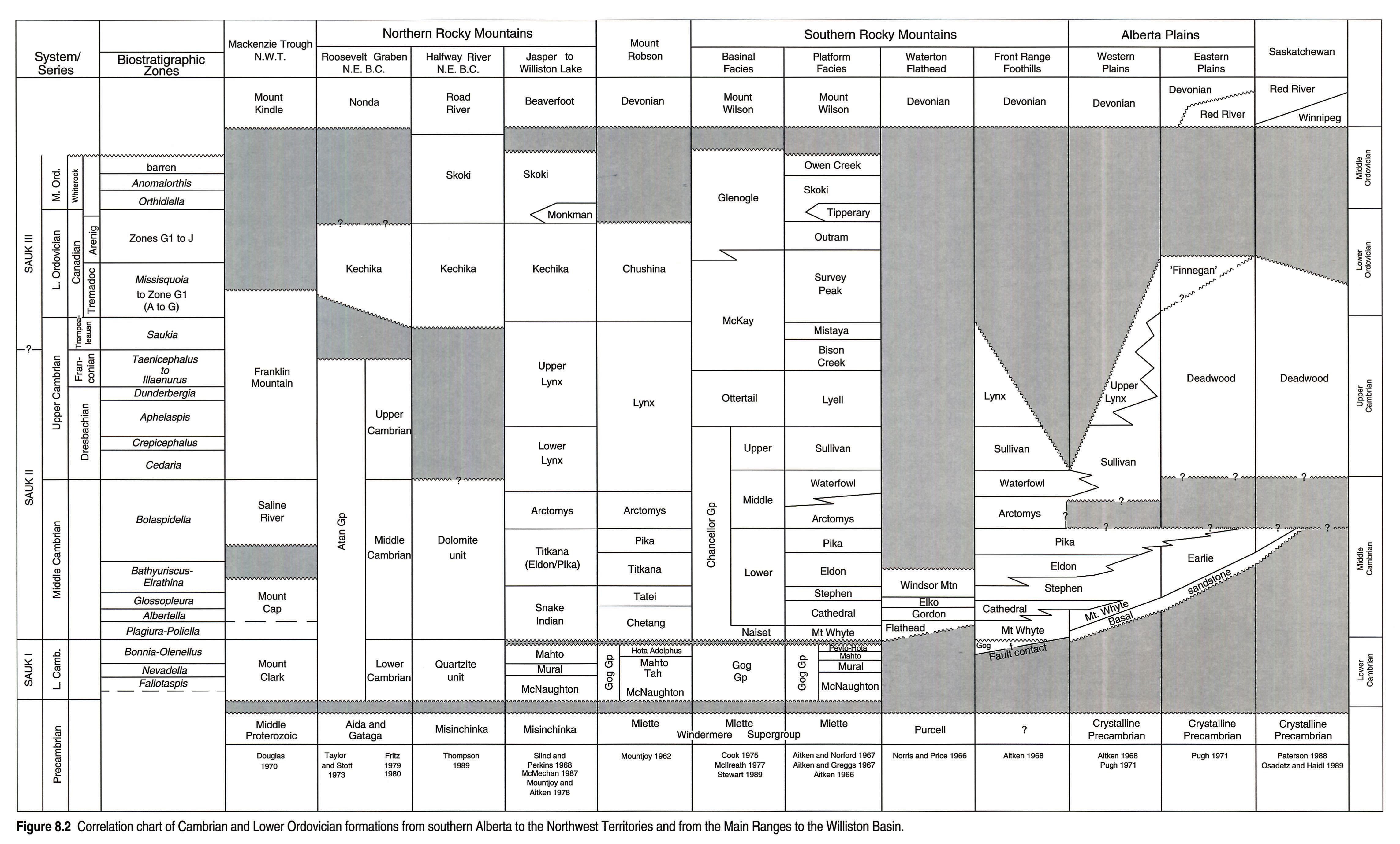
Cambrian and Lower Ordovician sediments are quite variable in thickness and lithology. Figure 8.2 lists the various formations and shows correlations throughout the basin. Included are formation names that appear in publications, although some unpublished work is included in our compilations.
The lower boundary of the interval is drawn at the top of the Lower Cambrian Gog Group, where there is commonly a disconformity or unconformity beneath the carbonates at the base of the Middle Cambrian. However, near the headwaters of the Bow River, there is no Gog quartzite above the Lower Cambrian Peyto Limestone, and the Peyto may be confused with the Middle Cambrian Mount Whyte Formation.
The top of the interval is picked below formations that are primarily Middle Ordovician: Winnipeg, Skoki, Monkman, Tipperary and Glenogle. The bases of these formations are not time equivalent and all but the Winnipeg include Upper Canadian (Lower Ordovician Arenig) horizons. Faunal control in the mountain sections is quite good but dating in the subsurface is based on very few control points.
Unconformities and areas of missing section are schematically shown on the chart (Fig. 8.2). A major question is whether or not there is a large unconformity between the base of the Deadwood Formation and the top of the Pika marker. The determination depends on what is interpreted to be the relationships with the apparently equivalent Arctomys and Waterfowl formations in central Alberta. The Finnegan Formation (Pugh, 1971) is shown on the chart for reference purposes, although we have not considered it as a mappable formation.
Stratigraphic Concepts
Based on extensive study of the Cambrian in the southern Rocky Mountains, Aitken (1966, 1971, 1978) has developed and applied a number of important stratigraphic concepts that help provide the framework for understanding the stratigraphy of the sequence in the western part of the basin. Three of these concepts are: facies belts, grand cycles and the Kicking Horse Rim. The latter, described previously, is illustrated in Figure 8.5 and further discussed under the heading Middle Cambrian-Platform.
Facies Belts
The sediments of the Middle Cambrian to Early Ordovician interval were deposited in one of three contiguous and temporally equivalent facies belts (Fig. 8.3). The "Inner Detrital Facies" was deposited on the craton in shallow to moderately deep inshore basins. The rocks are siltstone, shale and shallow-water sandstone with subordinate carbonate interbeds.
The "Middle Carbonate Shoal Facies" (also "eastern" or "platform facies") was deposited seaward of the Inner Detrital Facies and is characterized by a variety of shallow-water carbonates with minor amounts of clay, quartz sand and silt.
The "Outer Detrital Facies" ("western" or "basinal facies") lay seaward of the Middle Carbonate Shoal Facies and is composed of thin-bedded mudstone, siltstone and carbonate. The sediments were mainly deposited in deep water, although shallow-water carbonates occur in the Ottertail Formation, and the Monkman and Tipperary clastics appear to be of shallow-water origin.
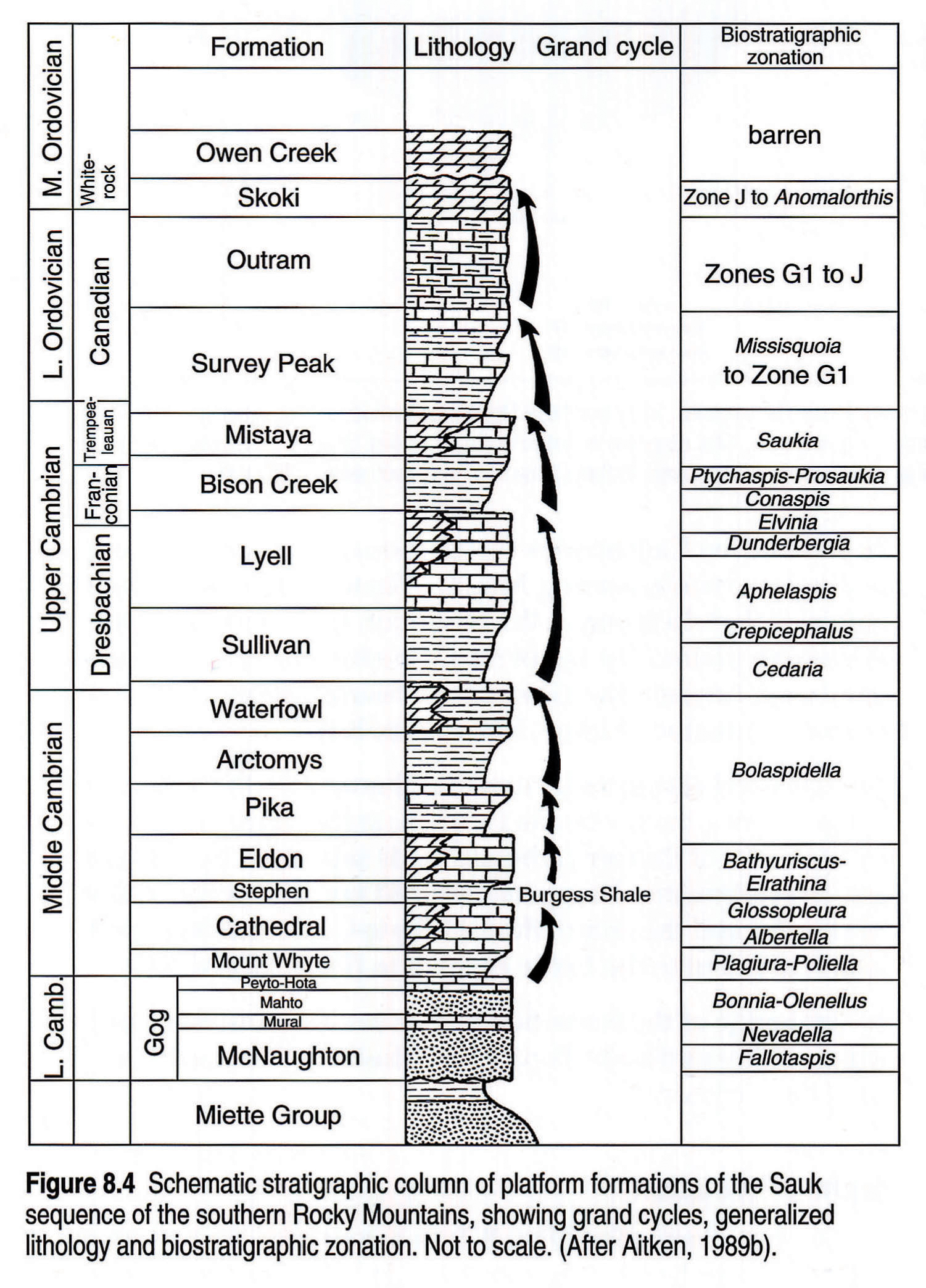
Grand Cycles
Deposition in the miogeocline and on the platform occurred in a series of eight repeating "grand cycles" of sedimentation, (Fig. 8.4). The cycles are best developed in the Main Ranges, beginning at the base of the Middle Cambrian and continuing into the lower Middle Ordovician. Each cycle is sharp-based and consists of a lower siliciclastic ("inner detrital") interval succeeded progressively upward by rocks of the "middle carbonate shoal" facies. The tops of the cycles approximate time lines but the bases of the carbonate facies are generally diachronous.
The sedimentary cycles are less apparent to the east, where clastics of the "inner detrital facies" replace many of the carbonates of each upper half-cycle.
Descriptions of Formations
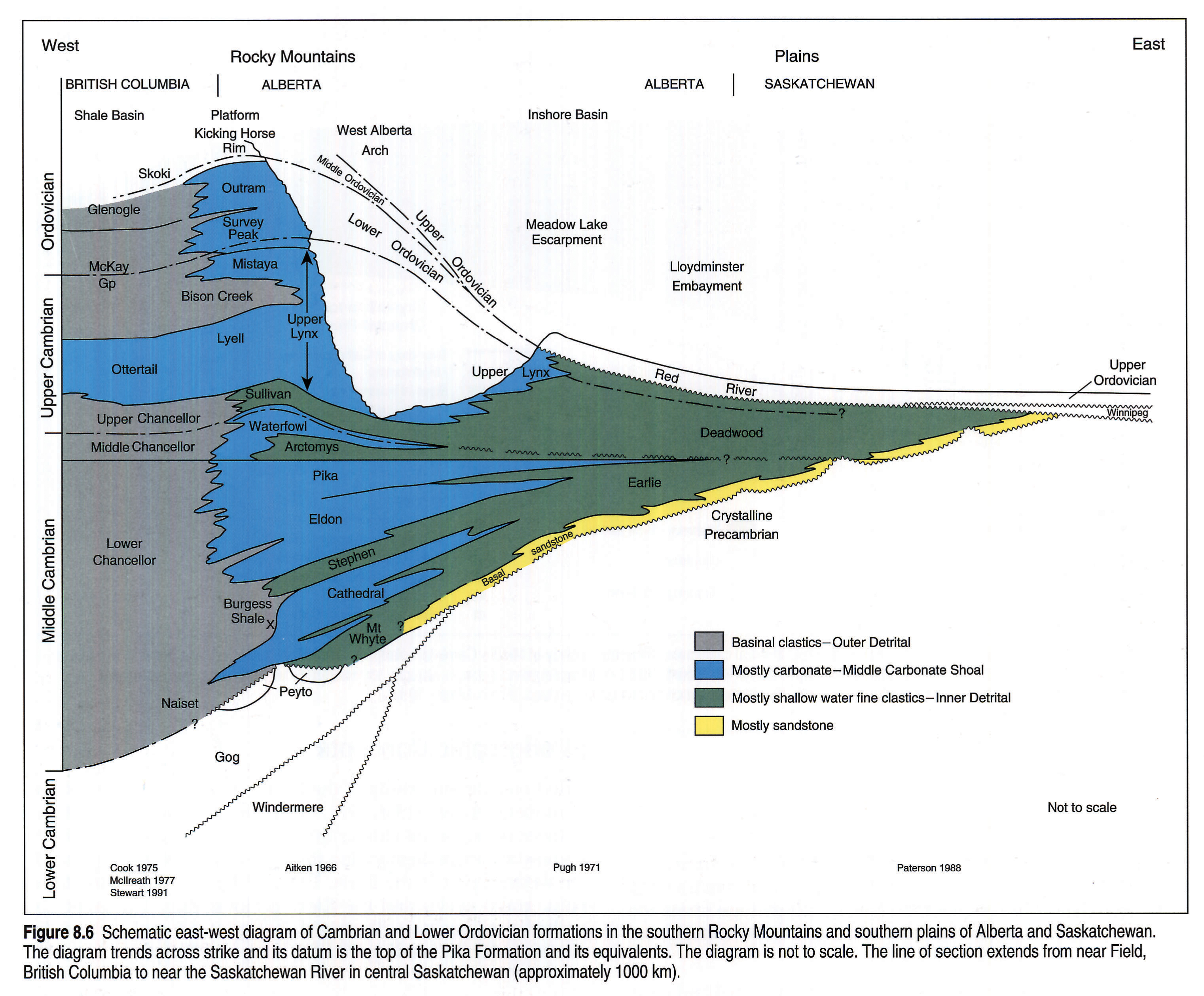
The southern Rocky Mountains contain the most complete and well studied sequence of Middle Cambrian to Early Ordovician rocks in the WCSB. The sequence is well exposed, biostratigraphic control is very good, and the Southern Rocky Mountain formations have been correlated, as far as possible, into the northern Rocky Mountains and western plains (Figs. 8.2, 8.4, 8.6, 8.7).
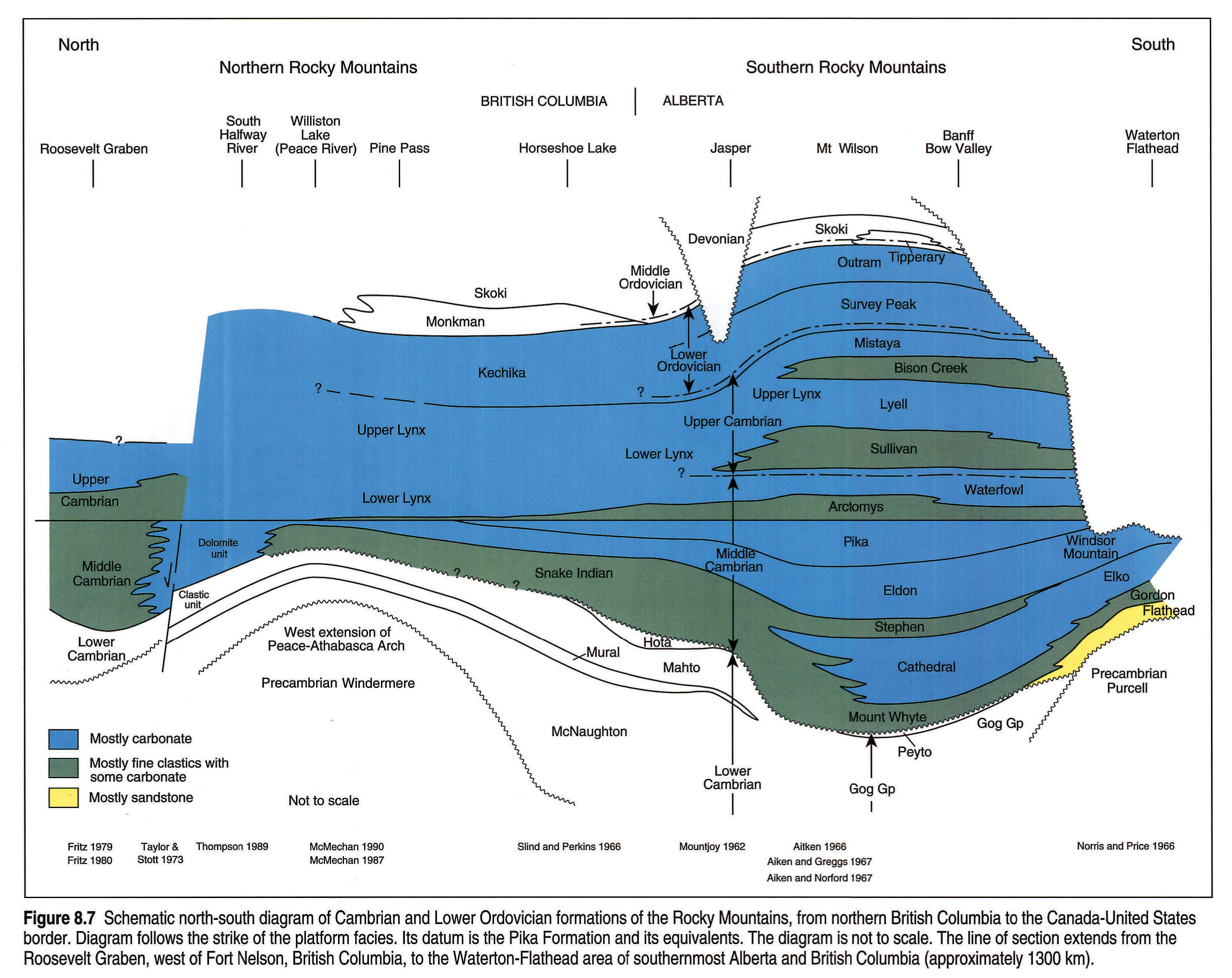
The platform formations of the southern Rockies are described first and used as a framework to discuss other formations in the WCSB (Fig. 8.2). More detailed descriptions are found in the works of Aitken (1968), Aitken and Greggs (1967), Aitken and Norford (1967), Cook (1975), and Pugh (1971, 1973, 1975).
Middle Cambrian - Platform
Mount Whyte Formation
The Mount Whyte Formation of the southern Rocky Mountains (Fig. 8.2) unconformably to disconformably overlies the Lower Cambrian Gog Group and underlies the massive carbonates of the Cathedral Formation (Fig. 8.6). It is up to 176 m thick and consists mainly of shale with interbedded limestone, siltstone and minor sandstone. The formation thins over the Kicking Horse Rim and is missing in several localities where the Cathedral lies directly on the Gog. It is the time equivalent of the Naiset Formation of the Outer Detrital belt.
In the subsurface of the plains, the formation is up to 60 m thick and is characterized by varicolored shales, micaceous and glauconitic siltstone, and minor sandstone. Generally it has a relatively high gamma-ray response.
The formation is mapped only where the overlying Cathedral Formation can be clearly identified. In the mountains, the Cathedral becomes more clastic-rich northward, where the Mount Whyte - Cathedral - Stephen interval is equivalent to the Snake Indian Formation (Fig. 8.7).
In the subsurface, the Mount Whyte is mapped eastward to the point where the overlying Cathedral carbonate disappears, beyond which the Mount Whyte to Stephen interval is replaced by the Earlie Formation (Fig. 8.10). The formation is time transgressive. It contains Plagiura-Poliella fauna in the Main Ranges, Albertella fauna at the mountain front and in the western plains, and the Glossopleura zone farther northeast (Fig. 8.5).
Cathedral Formation
The Cathedral Formation of the southern Rocky Mountains (Fig. 8.2) is a massive, cliff-forming dolomite and limestone that varies in thickness from 365 m in the Main Ranges to 160 m at the mountain front. The formation loses its massive character to the north and grades laterally into a series of alternating carbonate and clastic units of the Snake Indian Formation (Fig. 8.7). The formation terminates abruptly westward along the Kicking Horse Rim (Fig. 8.5), except for the Takakkaw Tongue of the "basinal" facies of the Cathedral Formation (Aitken, 1989a; Stewart, 1989).
The base of the Cathedral is diachronous; it conformably overlies the Plagiura-Poliella-bearing Mount Whyte Formation in the west, contains Albertella fauna at the mountain front and Glossopleura in the western plains. The top of the Cathedral is a near-synchronous zone lying beneath the Glossopleura-bearing shales of the lower Stephen Formation (Aitken, 1989a) (Fig. 8.5).
The Cathedral also loses its massive character in the subsurface. It changes from a thickly bedded carbonate formation in the foothills to a sequence of thinner carbonate beds separated by shales to the east. The carbonates disappear about 80 km west of the Saskatchewan border and the entire Mount Whyte-Cathedral-Stephen interval is equivalent to the Earlie Formation (Figs. 8.2 and 8.6).
The zero edge of the formation passes east of Edmonton and then swings to the northwest. Figure 8.12 illustrates the northern pinch-out of the Cathedral.
Stephen Formation
The Stephen Formation (Fig. 8.2) is a recessive unit of greenish shales and thin bedded limestones that lies between the massive carbonates of the Cathedral and Eldon formations. It has been informally divided into a normal, "thin Stephen" on the platform areas and a "thick Stephen" west of the Cathedral Escarpment (Fig. 8.5). The "thin" formation is 109 m thick at its type section, thins to 21 m at Ghost River, and is 370 m thick at Chaba River. In the mountains to the north, Snake Indian strata contain equivalents of the Stephen Formation. The Stephen thickens abruptly basinward of the west-facing Cathedral Escarpment where it contains the renowned Burgess Shale, famous for its unique soft-bodied fossil assemblages as well as a prolific skeletonized fauna (Pringle, 1989).
The Stephen of the subsurface is about 30 to 50 m thick and consists of green and purple micaceous shale with minor amounts of glauconitic and micaceous siltstone. The formation expands to the east as a result of a facies boundary with the overlying Eldon Formation (Fig. 8.6). Farther east, the Earlie Formation includes strata equivalent to the Stephen and Eldon formations.
Snake Indian Formation
The Snake Indian Formation (Fig. 8.2) is a 244 to 610 m thick sequence of marine shale interbedded with 30 to 50 m thick intervals of limestone. The formation is developed in the Rocky Mountains from Jasper Park to northern British Columbia. It lies on the Gog Group and is overlain by the Eldon Formation. The Snake Indian is correlated with the Mount Whyte, Cathedral and Stephen formations of the southern Rocky Mountains (Fig. 8.7), the Chetang and Tatei formations of the Mount Robson area, and the lower part of the Earlie Formation in the subsurface (Fig. 8.2).
Eldon Formation
The Eldon Formation of the Rocky Mountains (Fig. 8.2) is a massive carbonate that overlies the Stephen and Snake Indian formations. The formation is more widely distributed than the Cathedral and extends northward to the Murray Range. The formation is 490 m thick on Mount Stephen at Kicking Horse Pass (where it includes the Pika Formation) and thins to 240 m to the north and east. Westward the carbonate abruptly changes facies to basinal limestone and shale of the Chancellor Formation (Fig. 8.5).
The Eldon Formation forms the massive carbonate cliffs on Mount Yamnuska at the mountain front above the Bow River. The Eldon of the subsurface is best developed in the foothills, where it is a massive carbonate unit up to 200 m thick. The carbonate thins to the east as the formation changes facies from limestone to argillaceous limestone to shale. Most of the thinning takes place from the bottom up. Where the Eldon carbonate disappears, the Eldon-equivalent interval is part of the Earlie Formation, including Pugh's (1971) clastic facies (Figs. 8.2 and 8.6).
The "Eldon Marker" (Fig. 8.9) can be traced eastward from the last well-defined carbonate bed along a well-defined log pick. The Eldon Formation name is restricted to clean carbonate and minor interbedded argillaceous carbonate beds. In northwestern Alberta, from about Townships 60 to 70 and west of Range 10W5, the Eldon consists of two distinct members, a lower porous sandstone, and an upper dolomite (Fig. 8.12).
Pika Formation
The Pika Formation (Fig. 8.2) consists of dark-weathering, flaggy limestones and dolomites with minor intervals of shale near the base. The formation varies in thickness from 361 m in the west to about 90 m at the mountain front. Westward, the Pika Formation merges with the Eldon and passes into the basinal facies of the Chancellor Formation (Fig. 8.6).
The Pika of the subsurface is composed of an upper, dense limestone member underlain by micaceous splintery shale. The formation is up to 60 m thick in the western plains and the carbonate thins eastward, passing laterally into the Earlie Formation in eastern Alberta (Fig. 8.6). A "Pika Marker" log pick is carried eastward beyond the Pika Formation limit.
Correlation of the Pika Formation and the "Pika Marker" is generally quite reliable except near the erosional edges of the Cambrian or where log quality is bad. We are in general agreement with the identification of the Pika by previous authors, except in northwestern Alberta where we interpret the Pika Formation of Pugh (1971) to actually be the Waterfowl Formation (refer to the discussion of regional cross section H - H' and Fig. 8.12).
In the plains, the Pika Formation or Pika Marker (Figs. 8.9 and 8.10) is used to separate the Deadwood Formation (interpreted Upper Cambrian and Lower Ordovician) from the underlying Earlie Formation (Middle Cambrian). The Pika in the mountains is of late Middle Cambrian age and is overlain by later Middle Cambrian Arctomys and Waterfowl formations. The Middle Cambrian-Upper Cambrian boundary occurs in the upper part of the Waterfowl Formation (Figs. 8.6 and 8.7). There is no faunal evidence to help select the actual base of the Upper Cambrian within the Earlie-Deadwood interval of the plains and some of the lower Deadwood may correlate to the uppermost Middle Cambrian of the mountains.
Arctomys Formation
The Arctomys of the Rocky Mountains (Fig. 8.2) is composed of brightly coloured shales and subordinate carbonates. There is some evidence to suggest evaporites were once present. It is a recessive interval between the cliff-forming carbonates of the Pika Formation below and the Waterfowl Formation above. It is a useful mapping horizon in the mountains and western plains (Figs. 8.6 and 8.7). The formation ranges in thickness from 235 m in the Main Ranges to between 20 and 85 m within the Front Ranges. It contains abundant shallow-water features (mud cracks, ripple marks and salt casts).
The formation in the subsurface has a high gamma-ray response. It is from 10 to 25 m thick in the foothills and has been mapped as far east as the 11-27-49-8W5 well in the northern plains. Aitken (1968) and Pugh (1971) suggested that the Arctomys and Waterfowl formations of the mountains are cut out eastward by a sub-Sullivan unconformity and that there is a hiatus between the top of the Pika and the base of the Deadwood, but such a break is not recognized in the present synthesis. The Waterfowl and Arctomys formations are correlated a short distance into the plains where they thin eastward and at least a part of the Waterfowl is missing (Fig. 8.6). Eastward, the Arctomys and Waterfowl formations pass laterally into the lower Deadwood Formation (Fig. 8.9).
Waterfowl Formation
The Waterfowl (Fig. 8.2) is a resistant, cliff-forming carbonate and siltstone formation that lies gradationally above the Arctomys Formation and is sharply overlain by the Sullivan Formation. The formation is yellow, contains characteristic stylolites and beds of oolites and stromatolites, and becomes more sandy to the north along the mountain front. It is up to 183 m thick in the Main Ranges, as thin as 16 m in the Front Ranges at the Ghost River, and ranges from 30 to 50 m in thickness in the foothills.
The Waterfowl can be traced into the northwestern plains of Alberta (Fig. 8.9 and 8.12) and separates Arctomys clastics from Sullivan clastics. Under most of the western plains an expanded Sullivan Formation includes Waterfowl-equivalent strata.
In the mountains north of Jasper, the Sullivan clastics disappear and equivalent strata are present as part of the Lynx Formation (Fig. 8.7).
Middle Cambrian: Flathead-Waterton Area
Flathead Formation
The Flathead Formation (Fig. 8.2) occurs in wells and in outcrop in the southern part of the Rocky Mountains. It consists of interbedded quartz sandstones, mudstones and quartzites. Thickness varies from 2 to 50 m. The Flathead is correlated with the Basal sandstone unit of the subsurface of western Alberta and is considered to be early Middle Cambrian in age (Figs. 8.2 and 8.11 left pane, 8.11 right pane).
Gordon Formation
The Gordon Formation (Fig. 8.2) gradationally overlies the Flathead Formation and is gradationally overlain by the Elko Formation. The formation mainly consists of fissile, gray to grayish green, micaceous shale that is commonly variegated with brown or pale red. It contains thin interbeds of glauconitic sandstone and limestone beds up to 6 m thick. The formation is of early Middle Cambrian age (Plagiura-Poliella, Albertella and Glossopleura faunas), ranges in thickness from 30 to 88 m, and is equivalent to part of the Cathedral Formation (Figs. 8.2, 8.7 and 8.11 left pane, 8.11 right pane).
Elko Formation
The Middle Cambrian Elko Formation (Fig. 8.2) is composed of cliff-forming, gray, fine to medium crystalline dolomite with beds of limestone and gray shale near the base. Local zones of vuggy and intercrystalline porosity are developed. The formation is up to 155 m thick. The Elko Formation is correlated with the Cathedral Formation of the Banff area (Figs. 8.2, 8.7 and 8.11 left pane, 8.11 right pane).
Windsor Mountain Formation
The Windsor Mountain Formation (Fig. 8.2) abruptly but conformably overlies the Elko Formation and is truncated at the sub-Devonian unconformity (Fig. 8.11 left pane, 8.11 right pane). The formation is a dolomite and limestone succession that is up to 68 m thick on Windsor Mountain and contains Middle Cambrian Glossopleura or Bathyuriscus-Elrathina faunas.
Upper Cambrian - Platform
Sullivan Formation
In the mountains, the Sullivan Formation (Fig. 8.2) is a recessive sequence of greenish gray and brown shales interbedded with thin, platy, oolitic and bioclastic limestones. It grades upward into the massive carbonates of the Lyell Formation. The Formation is 424 m thick in the Main Ranges, thins to 61 to 92 m in the Front Ranges, and contains an abundant Cambrian Upper (Cedaria) fauna.
The Sullivan is correlated into the plains where it lies sharply above the Waterfowl and Pika formations, and gradationally below the Lynx Formation (Fig. 8.6). The Sullivan of the plains is entirely clastic and the beds consist of glauconitic and dolomitic siltstone, shale and local fine-grained sandstone. The thickness of the formation is quite variable, ranging up to about 100 m.
The formation is equivalent to the lower part of the Deadwood Formation farther east, and we suggest that beyond the eastern limit of clearly identifiable Lynx Formation, the Sullivan Formation expands laterally to embrace the full Deadwood Formation (Figs. 8.6 and 8.9).
Lynx Group - Lynx Formation
The Lynx Group (Fig. 8.2) is made up of a lower Lynx, containing the Waterfowl and Sullivan formations, and an upper Lynx embracing the Lyell, Bison Creek and Mistaya formations (Fig. 8.7). With the loss of the shale component of the Bison Creek northward and eastward, these subdivisions of the upper Lynx Group lose their identity northward in Jasper Park, along the mountain front, and in the western plains. There, the group is referred to as Lynx or Upper Lynx Formation and lies directly on the Sullivan Formation (Fig. 8.6).
Lyell Formation - the Lyell Formation is a massive, cliff-forming carbonate of Dresbach age that varies in thickness from 222 to 519 m (Fig. 8.2 and 8.10).
Bison Creek Formation - the Bison Creek Formation is a mainly recessive unit of gray and green shales with interbeds of argillaceous limestone. The Formation ranges in thickness from 61 to 192 m (Fig. 8.10).
Mistaya Formation - the Mistaya Formation is a cliff-forming unit of dense, silty carbonate. It ranges in thickness from 61 to 153 m and contains a Late Cambrian Saukia fauna (Fig. 8.2).
North of Jasper, the Waterfowl and Sullivan formations of the lower Lynx also lose their identity and become a part of the all-encompassing Lynx Formation of the northern Rocky Mountains (Fig. 8.7).
Upper Lynx Formation - the Upper Lynx Formation of the mountain front and western plains consists of laminated, light-coloured dolomite with minor limestone, and interbedded dolomitic siltstone and sandstone. The amounts of siltstone and shale increase to the east, and ultimately the entire formation changes to fine-grained clastics and becomes a part of the Deadwood Formation (Figs. 8.6 and 8.9).
Lower Ordovician - Platform
Survey Peak Formation
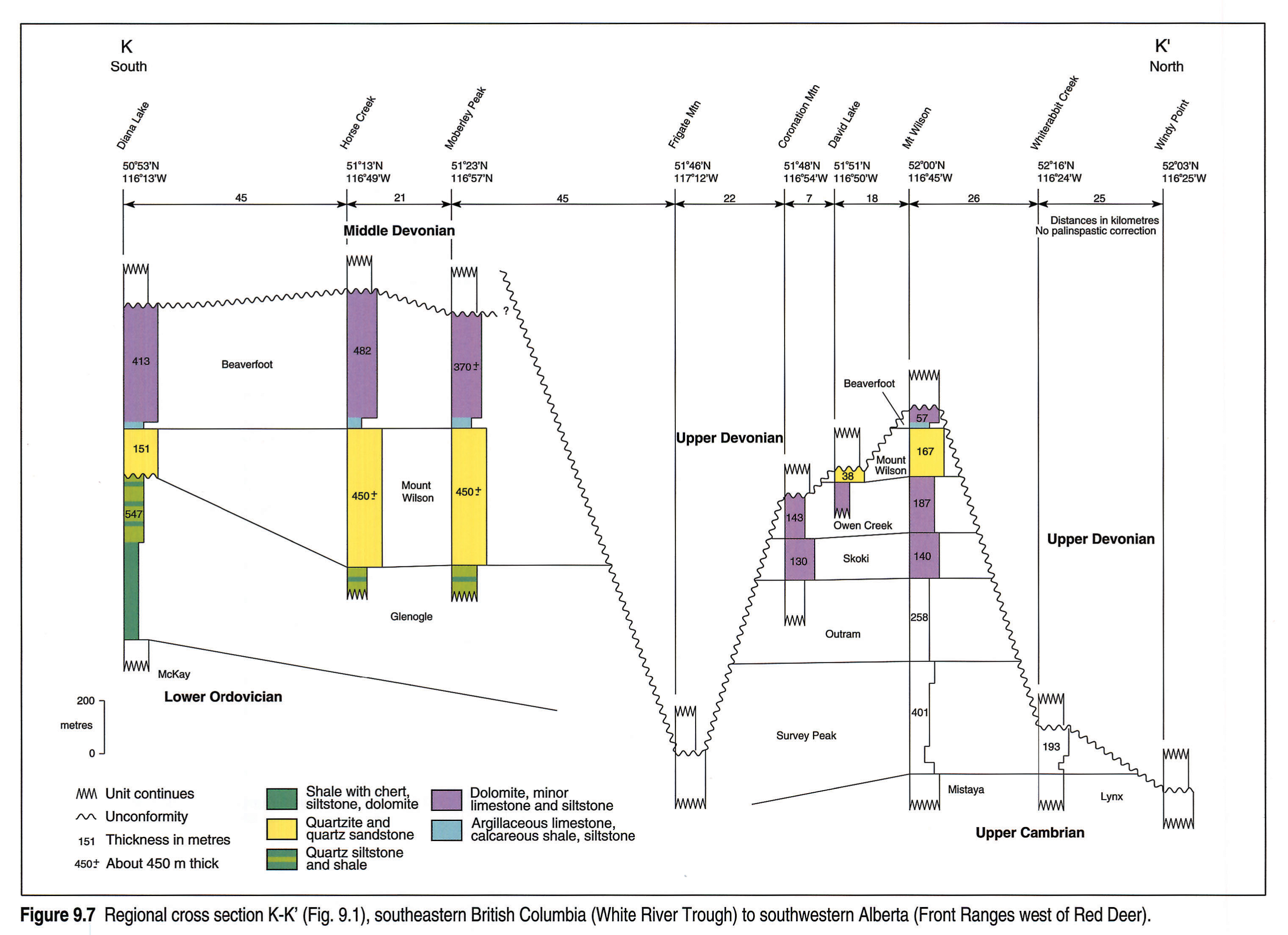
The Survey Peak Formation (Fig. 8.2) consists of a basal silty member 14 to 82 m thick, a putty coloured shale member 12 to 137 m thick, a middle member of limestone and shale up to 248 m thick, and an upper member of cliff-forming limestone 60 to 113 m thick. The contact with the underlying Mistaya Formation is abrupt and the upper contact with the Outram Formation is gradational. The formation contains an uppermost Cambrian fauna at its base and includes Ordovician trilobite zones A, B, D, E and probably F (Figs. 8.2, 8.6 and 8.7).
The lower members of the formation are equivalent to the Chushina Formation (obsolete) of Jasper Park (Fig. 8.2). The entire formation is eroded by the sub-Devonian unconformity at the mountain front and in the western plains (Fig. 8.6; see also Fig. 9.7, this volume). In Saskatchewan and eastern Alberta, the upper part of the Deadwood Formation may be the time-equivalent of part of the formation (Fig. 8.6).
Outram Formation
The Outram Formation (Figs. 8.6 and 8.7) is a recessive sequence of calcareous siltstones, dark limy shales, siliceous shales and clotted, nodular and laminated limestones. The formation is 170 to 443 m thick and restricted to the southern Rocky Mountains because of eastward downcutting of the sub-Devonian unconformity. The Outram has a gradational and diachronous contact with the overlying Skoki Formation that includes uppermost Lower Ordovician beds at its base (Fig. 8.2). The Outram contains Lower Ordovician trilobite zones G to J (Aitken and Norford, 1967).
Kechika Group
Eastern developments of the lower Kechika Group are lithologically similar to the coeval Survey Peak Formation (Fig. 8.7). The overlying Monkman Quartzite is developed locally (Fig. 8.7; see also Fig. 9.8, this volume) and is latest Early Ordovician in age. Western developments of the Kechika represent deeper depositional environments and are similar to the McKay Group. They are overlain diachronously by the deeper basinal sediments of the Road River Group (see Fig. 9.3, this volume), a similar relationship to the McKay-Glenogle transition in the southern Rocky Mountains (Fig. 8.6).
Middle Cambrian to Upper Cambrian- Basinal Facies
Middle Cambrian and most Upper Cambrian sedimentary packages change drastically from platform carbonates and minor clastics in the east to deep-water clastics and minor carbonates in the west.
Correlations between the two environments were established by Aitken (1971), Cook (1975), McIlreath (1977) and Stewart (1989), although there is some dispute in projecting the Cathedral Formation into the lower Chancellor as defined by Cook.
Naiset Formation
The Naiset Formation (Fig. 8.2) lies unconformably on the Gog Group and is overlain by the Cathedral Formation or its basinal equivalent (lower Chancellor?). The formation is 145 to 212 m thick and is composed of laminated, thin-bedded shale and siltstone, with minor limestone, sandstone and conglomerate. In places it contains platform talus blocks and debris flows. The Naiset is present only west of the present Kicking Horse Rim (Fig. 8.5). It contains Plagiura-Poliella Zone faunas and is correlated with the Mount Whyte Formation to the east.
Chancellor Formation
The Chancellor Formation (Middle-Upper Cambrian; Fig. 8.2) is the basinal equivalent of the entire Mount Whyte to Sullivan interval of the platform (Fig. 8.6). The Formation has been divided into three informal units by Cook (1975) but Stewart (1989) proposed that the Chancellor be upgraded to a group, comprising at least seven stratigraphic units. The unit has been tectonically deformed and thickness estimates are unreliable.
The lower Chancellor consists of argillaceous limestone, shale and thin bedded dolomite with chaotic slump folds, slope breccias and carbonate slide blocks. The lower Chancellor (Fig. 8.6) is equivalent to the Mount Whyte, Cathedral, Stephen, Eldon and Pika formations of the platform (Cook, 1975; McIlreath, 1977; Stewart, 1989). The "Takakkaw Tongue" of the Cathedral Formation occurs in the lower part (Fig. 8.5).
The middle Chancellor (Fig. 8.6) is composed of slate and cleaved, argillaceous limestone. Thin-bedded limestones of the upper part of the interval are biostratigraphically correlated with the Waterfowl Formation and the shales beneath are correlated with the Arctomys on a lithological basis (Cook, 1975).
The upper Chancellor (Fig. 8.6) comprises cleaved calcareous shale with thin to medium bedded limestone. It is transitional upward with the overlying Ottertail Formation. The unit is correlated with the Sullivan Formation of the platform.
Ottertail Formation
The Ottertail Formation (Fig. 8.2) is a cliff-forming unit, 460 to 610 m thick, composed of a basal unit of thin-bedded limestone and dolomite with interbedded shale overlain by thick-bedded limestone (Cook, 1975). The Ottertail is the westward continuation of the Lyell Formation and is unique in that the carbonate platform facies continues westward across former basinal areas (Fig. 8.6).
McKay Group
The McKay Group is a sequence of carbonates and shales, at least 2100 m thick (Mott et al., 1986), deposited in moderate water depths. The unit conformably overlies the Ottertail Formation and is overlain diachronously by the Glenogle Formation (Fig. 8.6). The McKay is Late Cambrian and Early Ordovician in age (Fig. 8.2) and equivalent to the Bison Creek-Mistaya-Survey Peak succession of the platform.
Glenogle Formation
The McKay rocks are succeeded by the deeper basinal sediments (argillaceous limestones, shales and limestone) of the Glenogle Formation (up to 850 m thick) of late Early and Middle Ordovician age (Fig. 8.2). The facies change to the Glenogle Formation westward from the coeval Outram, Tipperary and Skoki formations of the platform (see Fig. 9.6, this volume), is at the Kicking Horse Rim, with turbidite tongues of quartz sand from Tipperary Quartzite demonstrating a significant slope.
Interior Platform
Formations established in the southern Rocky Mountains are correlated as far as possible into the Interior Plains, but where they lose their identity, subsurface formations are established. These eastward transitions are illustrated on the regional cross sections (Figs. 8.8 left pane, 8.8 right pane, Fig. 8.9, Fig. 8.10, 8.11 left pane, 8.11 right pane).
Basal Sandstone Unit
The Basal sandstone unit is composed mainly of coarse-grained sandstones lying unconformably on a variably rugged topography of Precambrian crystalline rocks. The sandstone unit is locally missing but generally ranges in thickness from 17 to 115 m and is continuous throughout most of the plains. The effective porosity of the sands ranges from excellent to poor but no hydrocarbons are known from the unit. The sandstone is overlain by fine-grained clastic deposits of the Mount Whyte, Earlie or Deadwood formations, which generally display a relatively high gamma-ray response. The unit is strongly time transgressive, lying beneath the Cathedral Formation in 4-12-15-27W4 in southwestern Alberta and beneath the Upper Cambrian in southeastern Saskatchewan (Fig. 8.6).
Earlie Formation
The Earlie Formation (Fig. 8.2) is a sequence of interbedded siltstones, fine-grained sandstones, and shales that overlies the Basal sandstone unit and is overlain by the Pika or Deadwood formations (Pugh, 1971). The top of the Earlie is selected at the base of a thin Pika Formation, and where the Pika disappears, a gamma-ray marker, the "Pika Marker", determines the top (Fig. 8.10).
The formation is greater than 250 m thick along the Alberta-Saskatchewan boundary (Fig. 8.20) but is completely removed by erosion at the sub-Devonian unconformity north of the Meadow Lake Escarpment, and pinches out and is overstepped by the Deadwood Formation in Saskatchewan (Fig. 8.6). In the western Interior Plains the Earlie is equivalent to the Mount Whyte-Cathedral-Stephen-Eldon-Pika interval (Fig. 8.6).
Deadwood Formation
The Deadwood Formation (Fig. 8.2) consists mainly of interbedded shales and siltstones. The shales are green or purple, fissile and micaceous, and the siltstones are white to pale brown, green or pink, micaceous and glauconitic. The few limestone beds are pale buff to white, micritic or chalky. In southeastern Alberta the formation is less silty and contains more limestone. Silt content increases northward, and north of the Meadow Lake Escarpment in Alberta the lower part of the Deadwood consists of glauconitic siltstones and fine-grained sandstones.
Internal correlations of the Deadwood based on gamma-ray markers have been presented by several authors (Pugh, 1971; van Hees, 1964; Suska, 1963; Tawadros, 1988) and some disputes exist. We have therefore only shown Pugh's markers on portions of several of the regional cross sections and one type log (Fig. 8.18) and have not consistently carried interval correlations on all sections.
The Deadwood contains faunas of Late Cambrian and Early Ordovician age (Fig. 8.2) and is equivalent to the Sullivan and Lynx formations of the mountain front and the foothills, and possibly part of the Arctomys and Waterfowl formations (Fig. 8.6). The upper part of the Deadwood is coeval with parts of the Survey Peak and possibly parts of the Outram Formation of the Main Ranges (Fig. 8.6).
The Deadwood is more than 300 m thick along the Alberta-Saskatchewan boundary and is missing because of sub-Devonian erosion north of the Meadow Lake Escarpment (Fig. 8.13) and along the southern flank of the Peace-Athabasca Arch. The formation thins by sub-Devonian erosion in west-central Alberta and is completely cut out in southwestern most Alberta (south of 51°N), along the West Alberta Arch (Fig. 8.11 left pane, 8.11 right pane). The formation is unconformably overlain by the Winnipeg Formation in eastern Saskatchewan.
Finnegan Formation
Pugh (1971) established the Finnegan Formation (Fig. 8.2) in central Alberta in the Mobil Oil-CPR Hutton 11-18-24-15W4 well. The formation consists of interbedded micaceous and glauconitic siltstones, shales and subordinate limestone beds lying unconformably on the Deadwood Formation and overlain by the Middle Devonian Elk Point Group. The formation is up to 100 m thick and has been mapped in east-central Alberta.
Finnegan development is best shown on Pugh's (1971) cross section Q - C, between wells 4-5-41-2W5 and 10-16-38-20W4, where he interprets a major sub-Finnegan unconformity cutting out at least 150 m of Deadwood. On the basis of our correlations, and log and sample work by Tawadros (1988), we do not interpret the "Finnegan" to be a mappable formation but rather the distal eastern extremity of the Lynx Formation where its interbedded clastics and carbonates change facies into the Deadwood Formation.
Biostratigraphic Control
Extensive faunal collections have been made from the outcrops of the Rocky Mountains and identifications and zonations can be found in the publications of Walcott, Deiss, Rasetti, Aitken, and more comprehensively in papers by Fritz and Norford. The few faunal control points in the subsurface are listed below:
Commonwealth No. 1 (8-9-3-15W4), van Hees (1959; after Warren), Middle Cambrian fauna found near top of Cambrian section;
Texaco Wood Mtn. 12-10 (12-10-5-8W3), van Hees (1964), Late Cambrian Dresbach fauna from the Deadwood;
Calstan Parkland 4-12 (4-12-15-27W4), Raasch and Campeau (1957), Middle Cambrian fauna of the Albertella, Bathyuriscus-Elrathina and Thompsonaspis zones identified (Thompsonaspis no longer recognized as a formal zone);
Calstan Princess CPR No.1 (13-22-20-12W4), van Hees (1959; after Kirk), Late Cambrian fauna at top of Cambrian section;
Imperial Provost No.2 (1-33-37-3W4), van Hees (1959; after Bell), early Late Cambrian fauna;
Rio Bravo Ronald 1-6 (1-6-38-15W4), Hutchinson (1960), Middle Cambrian Glossopleura at 8022 ft.;
Calstan East Gilby 4-5 (4-5-41-2W5), van Hees (1959; after Raasch), Late Cambrian Crepicephalus at 10 485 ft.;
Texaco Wizard Lake B-3 (15-21-48-27W4), van Hees (1959; after Raasch), Middle Cambrian late "Stephen" trilobite from 9300 ft.;
Imperial Leduc 530 (8-17-50-26W4), Raasch (1984), Middle Cambrian, late "Stephen" fauna at 8662 ft.;
Fina et al. Windfall 12-36 (12-36-59-15W5), Raasch and Campeau (1957), Middle Cambrian Glossopleura at 10 923 ft.;
Imperial Blue Bell (2-13-60-20W3), Porter and Fuller (1958), Late Cambrian fauna found between 2707 and 2726 ft.;
Imperial Virginia Hills 6-36 (6-36-63-12W5), Raasch (1984), a single obolid brachiopod given a questionable Middle Cambrian (Bathyuriscus - Elrathina Zone) age.
Several important wells in northern Montana have Late Cambrian and Early Ordovician faunas (Lochman-Balk and Wilson, 1967).
Regional Cross Sections
Introduction
Regional cross sections, using well logs and outcrops, illustrate the formation and unit relations of the Middle Cambrian to Early Ordovician sediments from the Rocky Mountains to their pinch-out and truncation on the Canadian Shield (Figs. 8.8-8.15). The foothills and Rocky Mountain sections are palinspastically restored, to show their original depositional positions.
The sections are referenced to a datum drawn at the top of the Pika Formation in the western part of the basin and on the "Pika Marker" in eastern Alberta and Saskatchewan. The correlations are well established through most of the basin, although the Pika Marker deteriorates to the northeast.
Formation names from the Rockies are carried as far east as possible and in a few cases log markers associated with the formations are extended out into the monotonous fine-grained clastic intervals of the plains.
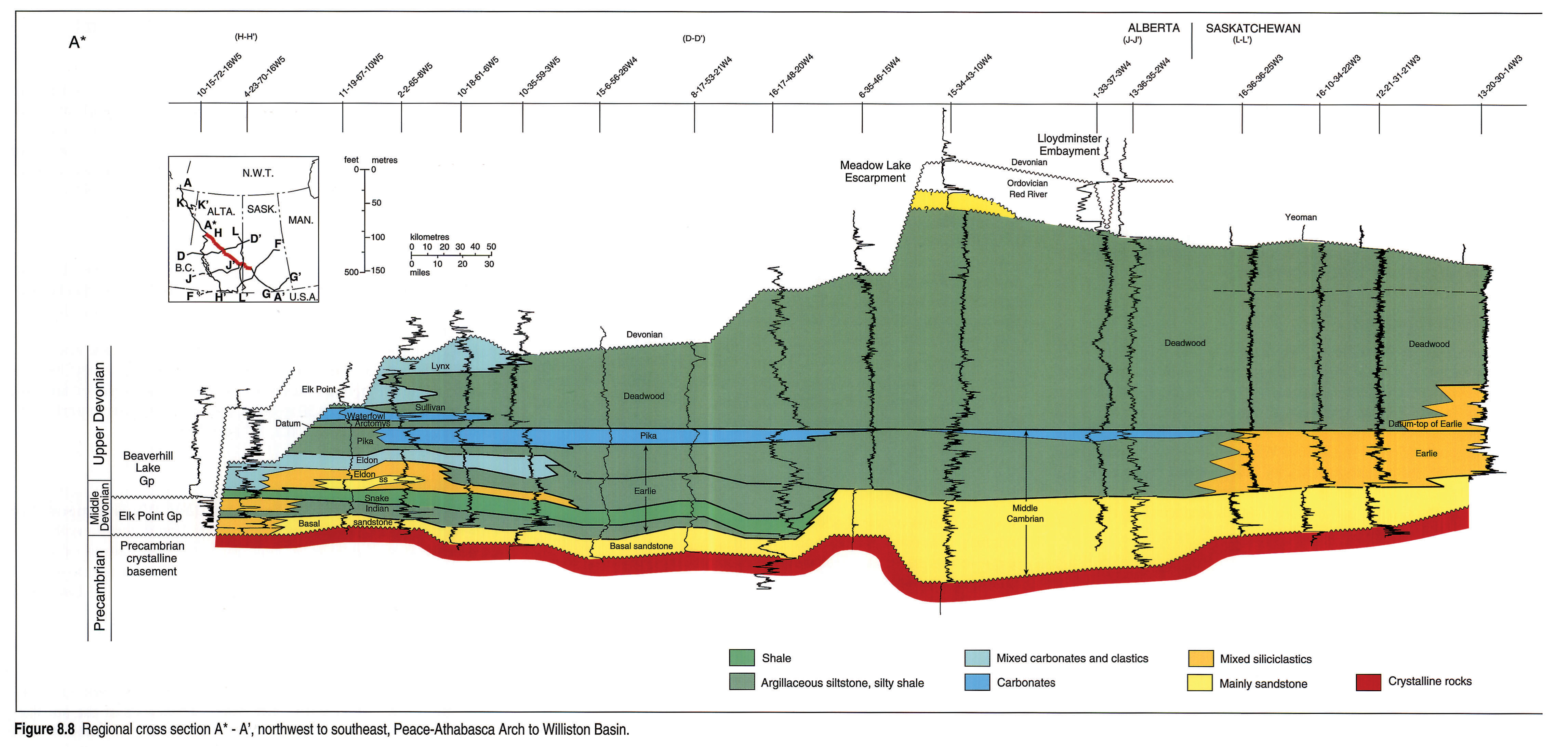
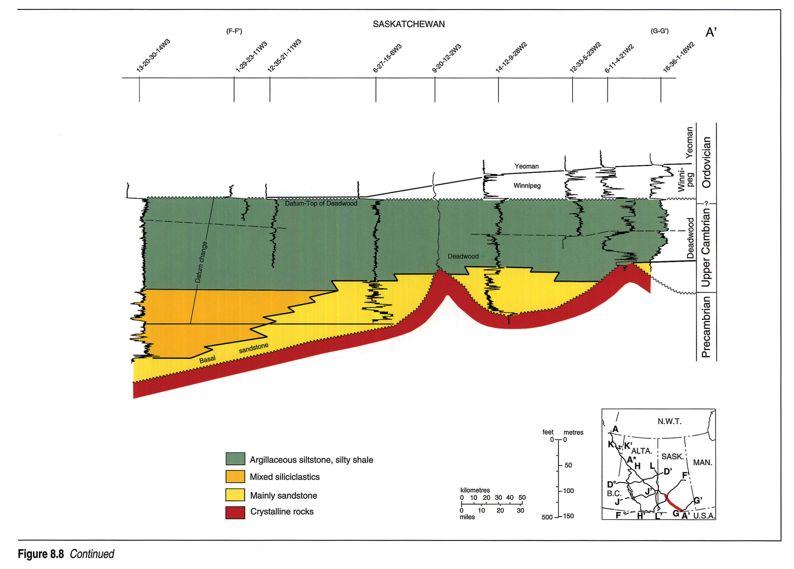
Section A* - A'
The A* - A' section (Fig. 8.8 left pane, 8.8 right pane) stretches from the flank of the Peace-Athabasca Arch in the northwest, where the entire Cambrian has been removed by early Devonian erosion, southeastward to the edge of the Williston Basin. Differentiation between Cambrian basal sands and basal Devonian clastics is difficult in the arch area. Where the local sands are immediately overlain by Devonian formations they are included in the Devonian Granite Wash, and where they are overlain by identifiable Cambrian units, the sands are regarded as Cambrian.
Thinning of the Cambrian section to the northwest is largely due to sub-Devonian erosion, although some is due to onlap toward the Peace-Athabasca Arch. The section is thickest below the Meadow Lake Escarpment and thins southeastward by onlap onto the Canadian Shield. Strata along section A* - A' (Fig. 8.8 left pane, 8.8 right pane) are composed mostly of clastics, and significant carbonates are present only in the thin Pika and Waterfowl formations to the northwest. We disagree with Pugh (1971) in that we consider his Pika in the 10-18-61-6W5 well (Pugh's cross section T-E-D) to be Waterfowl (see discussion of section H - H').
An Eldon sandstone unit is developed in the northwestern well, 11-19-67-10W5. This thick clastic unit is eroded to the north and pinches out to the southeast. The unit is mappable over a large area south of the Peace River Arch (Fig. 8.12). The top of this unit is placed on top of oolitic and dolomitic quartzarenites (a few metres below the top of the Eldon Marker), and its base is placed at the top of the Stephen Formation.
At the edge of the Meadow Lake Escarpment, the 15-34-43-10W4 well penetrates a prominent clean quartz sandstone unit 25 m thick that lies beneath Ordovician Yeoman carbonates and above typical Deadwood. The sandstone is thought to be a remnant of the Middle Ordovician Winnipeg Formation but the Winnipeg is normally restricted to eastern Saskatchewan. The deeper part of this well penetrates a thick development of Middle Cambrian Earlie and Basal sandstone adjacent to a Precambrian high encountered in 6-35-46-15W4.
From west-central Saskatchewan to southeastern Saskatchewan the Cambrian section thins against a rising Precambrian surface. The coarse clastics of the Basal sandstone are diachronous, containing Earlie-equivalent strata in the west to Deadwood-equivalent strata in the east. The sands are prominently developed around Precambrian highs in the southeast. These highs are interpreted as erosional monadnocks, although some may have a structural origin. The Earlie Formation pinches out against the Precambrian surface to the east. The overlying, monotonous, fine-grained siliciclastics of the Deadwood Formation become coarser and more variable as they overlap the Earlie Formation to the southeast, and are unconformably overlain by the Middle Ordovician Winnipeg Formation.
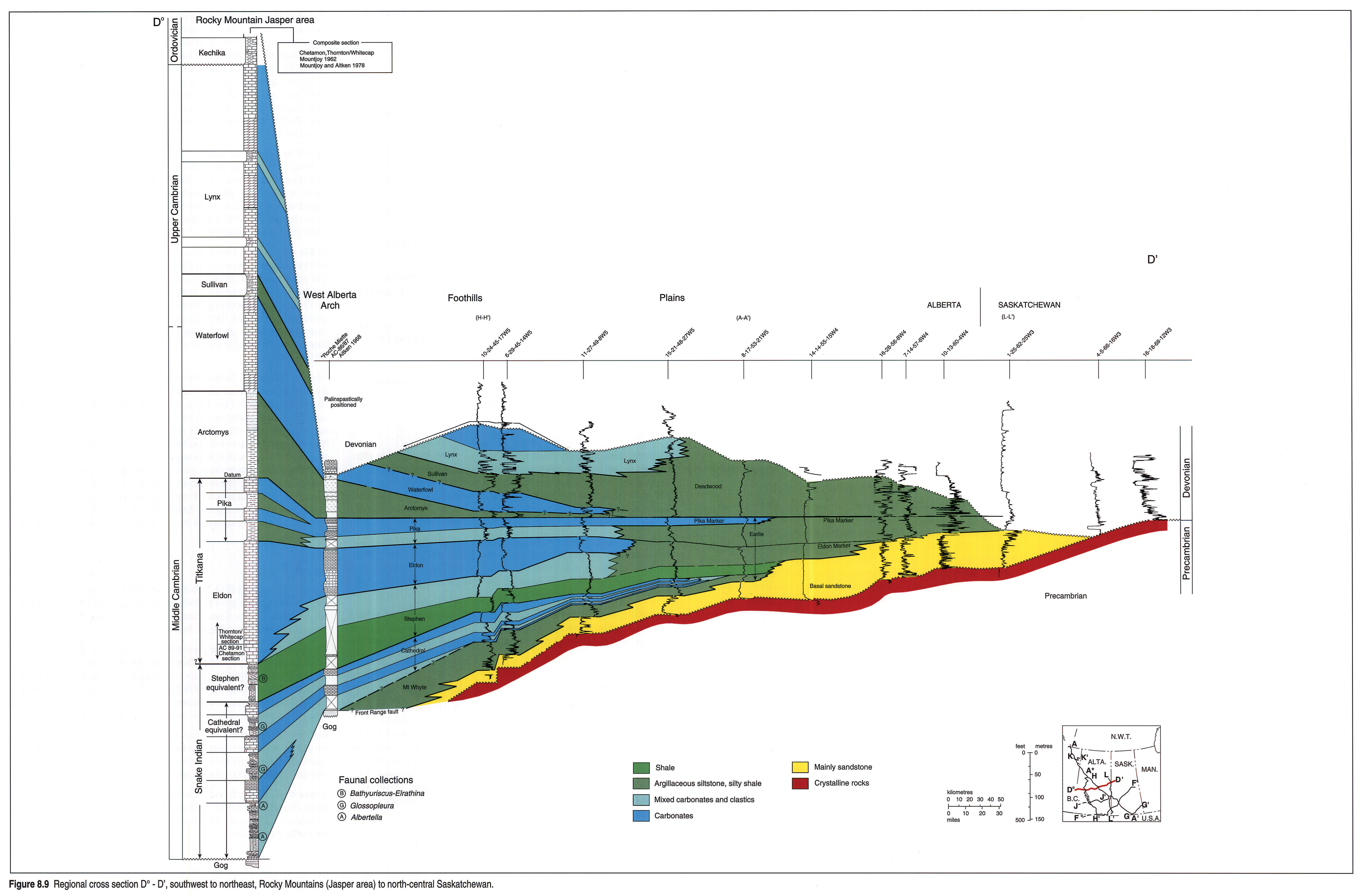
Section D° - D'
The D° - D' section (Fig. 8.9) dramatically illustrates the eastward truncation of the Upper Cambrian at the sub-Devonian unconformity. A thin Upper Cambrian occurs near Roche Miette, close to the axis of the West Alberta Arch.
The Devonian-Cambrian boundary is locally difficult to determine. In the west, Devonian Beaverhill Lake carbonates commonly lie directly on Cambrian Lynx carbonates, with no intervening Elk Point clastics. Farther east, Elk Point clastic redbeds lie on reddish Cambrian siltstones, sandstones and shales. The presence of abundant glauconite is used to identify the Cambrian.
Sections D° - D' and J - J' (Fig. 8.10) provide for correlations from the Rocky Mountain sections to the plains. Faunal control is very sparse and correlations are generally made using carbonate intervals and their marker equivalents.
Where the Cathedral and Eldon carbonates disappear eastward by facies change, the Mount Whyte clastics merge with Stephen and Cathedral, Eldon and Pika clastic equivalents, and are mapped as the Earlie Formation.
The Upper Cambrian grand cycles are not well developed in the plains, although the Sullivan and Arctomys clastics, the Lynx carbonates and Waterfowl carbonates and clastics are recognized east of the foothills. Where the Lynx is not identifiable, the entire Upper Cambrian (and Lower Ordovician) section is mapped as the Deadwood Formation.
The Basal sandstone unit is thick in the northeastern third of the section but thins abruptly near 8-17-53-21W4. Toward the foothills it thins gradually, by facies transition.
The east end of this section shows the progressive erosional truncation of the Deadwood Formation, Earlie Formation and Basal sandstone. The erosional slope is buried by the red siltstones and shales of the Devonian Meadow Lake Formation.
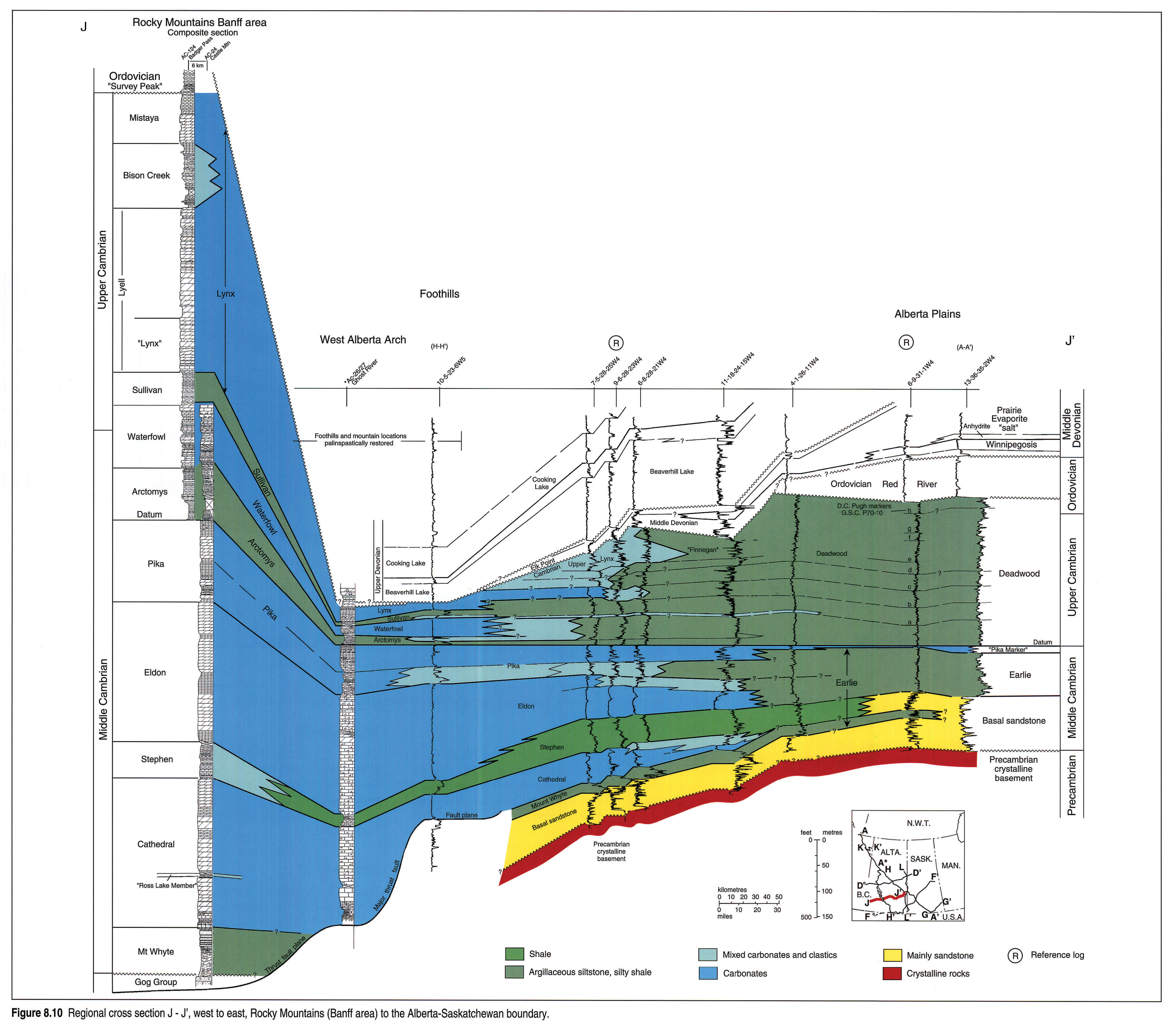
Section J - J'
The J - J' section (Fig. 8.10) strikes east-west across Alberta and intersects A* - A' near the Saskatchewan border (13-36-35-2W4) and section H - H' (Fig. 8.12) in the subsurface thrust sheet at Moose Mountain (10-5-23-6W5). The west end of the section includes outcrop sections at Ghost River and Castle Mountain.
Generally the section shows the transition from clastics (silty shales) in the east to marine carbonates and shales in the west. The Basal sandstone unit extends across the section and interfingers westward with the Mount Whyte and Stephen formations.
The Middle Cambrian, massive, cliff-forming carbonates of the Cathedral and Eldon formations at Castle Mountain gradually thin and interfinger with the siltstones and silty shales of the Earlie Formation to the east. The Arctomys, Waterfowl, Sullivan, and Lynx formations of the mountains are shown to grade eastward into the silty shales of the Deadwood Formation. Aitken (1966) contended that the Waterfowl and Arctomys are cut out eastward by an unconformity at the base of the Sullivan Formation. Pugh's (1971) type section of the Finnegan Formation is indicated on 11-18-24-15W4 and 6-8-28-21W4, and his internal Deadwood correlations are shown on the eastern part of the section.
The subdued southern continuation of the Meadow Lake Escarpment is apparent on the section but the relief on the feature in Middle and Late Devonian time was minimal, quite different from the substantial Early and Middle Devonian topography it exhibited farther north. The downcutting of the Upper Cambrian over the West Alberta Arch and subsequent onlap of the Devonian are best illustrated in the centre of this section.
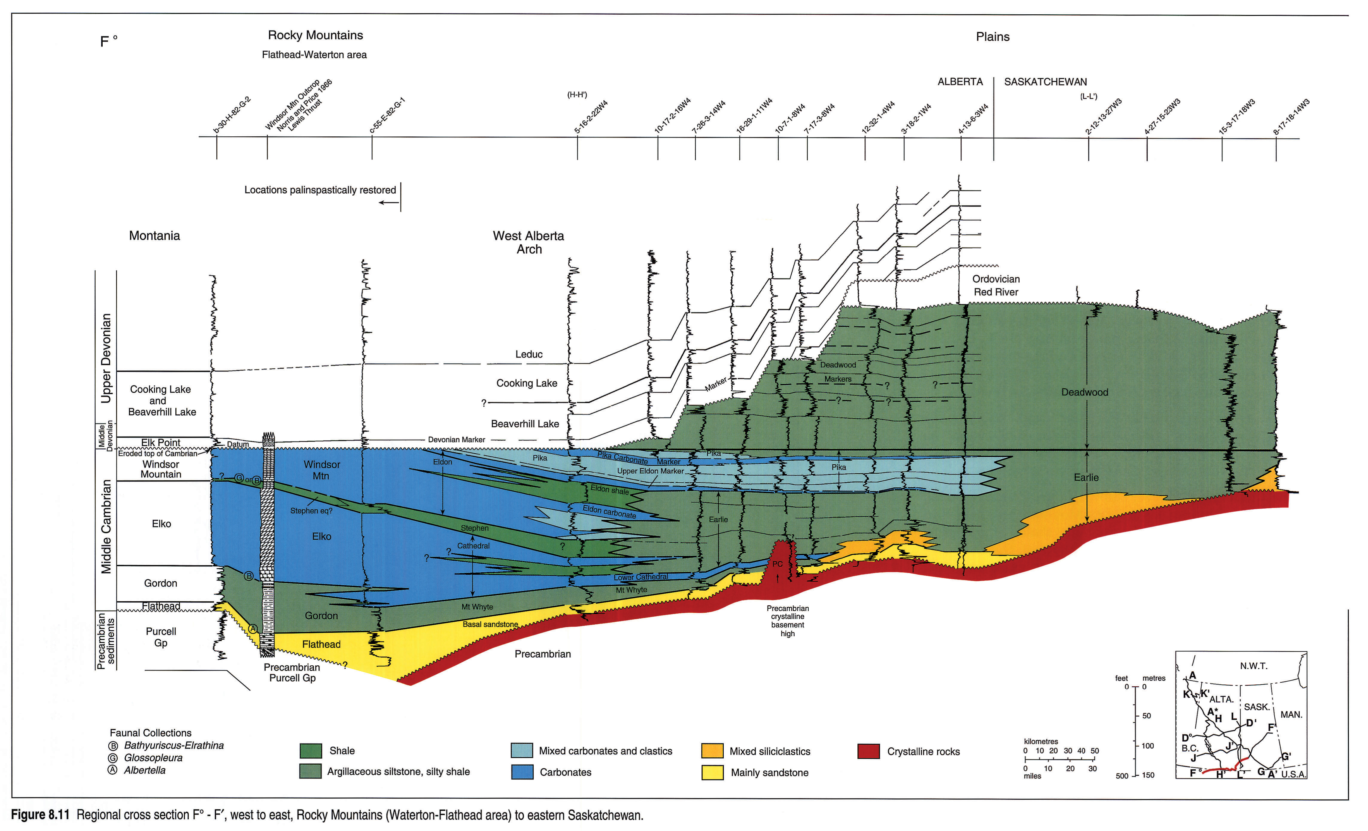
Section F° - F'
This F° - F' section (Fig. 8.11 left pane, 8.11 right pane) includes a deep well west of the Lewis Thrust plate in southeastern British Columbia, an outcrop section lying on the Lewis Thrust, and a thrusted section in a well beneath the Lewis Thrust. It continues eastward to the Saskatchewan border and shifts northeastward to terminate in eastern Saskatchewan.
The west end shows Middle Cambrian clastics lying unconformably on the Precambrian Purcell Group of Montania, with the Flathead Sandstone equivalent to the Basal sandstone unit.
The results of sub-Devonian erosion along the West Alberta Arch are marked along the western part of the section, where all of the Upper Cambrian and part of the Middle Cambrian have been removed. Erosional reduction of the Cambrian continues eastward to near the Saskatchewan border where Upper Ordovician carbonates protect the interval, as they do along the Meadow Lake Escarpment. Precambrian highs, interpreted as monadnocks, are common in southern Alberta and Saskatchewan and the Middle Cambrian sediments thin over or pinch out against them.
In Saskatchewan the section shows monotonous, fine-grained siliciclastics of both the Earlie and Deadwood formations pinching out eastward against a rising Precambrian surface. Both formations contain coarser rocks toward the craton and away from the deeper basinal area in Alberta. The Basal sandstone unit is absent in part of this region of Saskatchewan but is present to the north and south. The Middle Ordovician Winnipeg Formation overlies the succession in the northeast, and elsewhere the section is overlain by the carbonates of the Upper Ordovician Yeoman Formation.
Section H - H'
The H - H' section (Fig. 8.12) is oriented north-south, stretching from the northwestern plains of Alberta, through the major thrust sheets of the foothills, to the undisturbed western plains near the Alberta-Montana border. The section provides a good tie to the east-west mountains-to-plains sections (Figs. 8.9-8.11) in an area where most of the Middle Cambrian grand cycles are well developed. The Late Cambrian cycles of the Main Ranges are not apparent along the line of section and only the Lynx and Sullivan formation names are used.
In this section, the upper Sullivan shale facies passes laterally into the time-equivalent lower Lynx carbonate facies. Where the contact is gradational and shales are interbedded with lower Lynx carbonates, the top of the Sullivan is usually picked at the base of the lowermost thick carbonate bed of the Lynx.
Section H - H' agrees quite well with published data except at the north end and in one well at the south. There is a significant disagreement with previous authors on the identification of the Pika and Waterfowl formations in the northwestern part of Alberta, south of the Peace-Athabasca Arch. Compare the 10-15-63-15W5 well on section H - H' to Pugh's (1971) line T-E-D. Following Tawadros (1988), the carbonate member referred to as Pika in Pugh's (1971) section T-E-D and his 1973 section V - W, is interpreted here as Waterfowl. A Pika correlation is carried from the mountains into the foothills and along the western side of the basin. Sections J - J' and D° - D' show the relevant correlations (Figs. 8.9 and 8.10). This opinion is supported by lithological similarities between the Waterfowl of the mountains and Pugh's "Pika" of the region in question. There is no biostratigraphic evidence to support either position.
At the northern end of the cross section, a sand facies with significant porosity is developed within the Eldon Formation. These sands were probably derived from the Peace - Athabasca Arch to the north (Tawadros, 1988).
In many foothills wells, limestones of the Upper Devonian Beaverhill Lake Group rest directly upon Upper Cambrian Lynx limestone without any intervening Elk Point shale to help define the geological contacts. Oolites in the Cambrian and stromatoporoids in the Devonian are useful aids in selecting the contact.
Section H - H' includes the 4-12-15-27W5 well that also appears on Pugh's (1971) section P-V-B. Raasch and Campeau's (1957) Cambrian top at 10 530 ft. (log depth) is accepted here and is correlated with the Pika Formation top of southern Alberta.
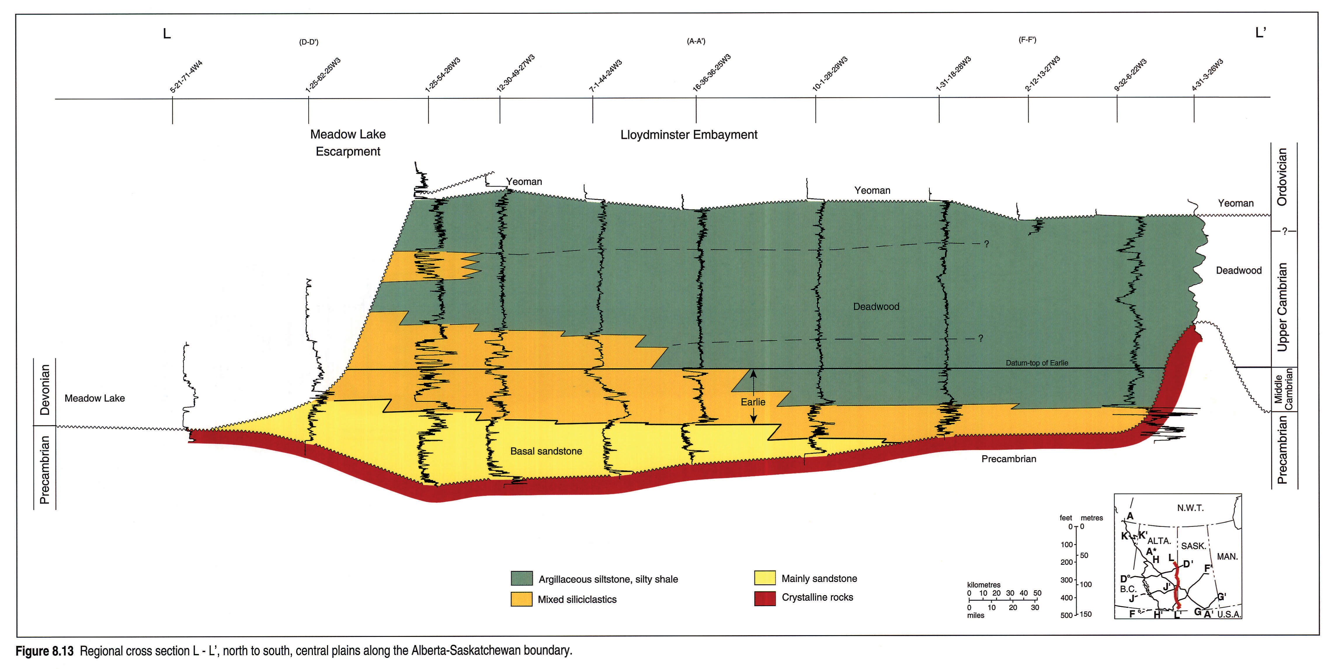
Section L - L'
The L - L' section (Fig. 8.13) runs from north to south along the Alberta-Saskatchewan boundary. At the south end, the Earlie Formation is absent and the Deadwood Formation thins over a local Precambrian high (one of several in the region). The Earlie and Deadwood formations are both composed of fine- to medium-grained siliciclastics, and thickening occurs northward into the Lloydminster Embayment, accompanied by an increase in grain size. The Cambrian strata are abruptly terminated in northern Saskatchewan by erosion, forming the slope of the Meadow Lake Escarpment. There is no sign of depositional thinning northward in either the Earlie or Deadwood, and it can be assumed that both formations originally extended much farther north.
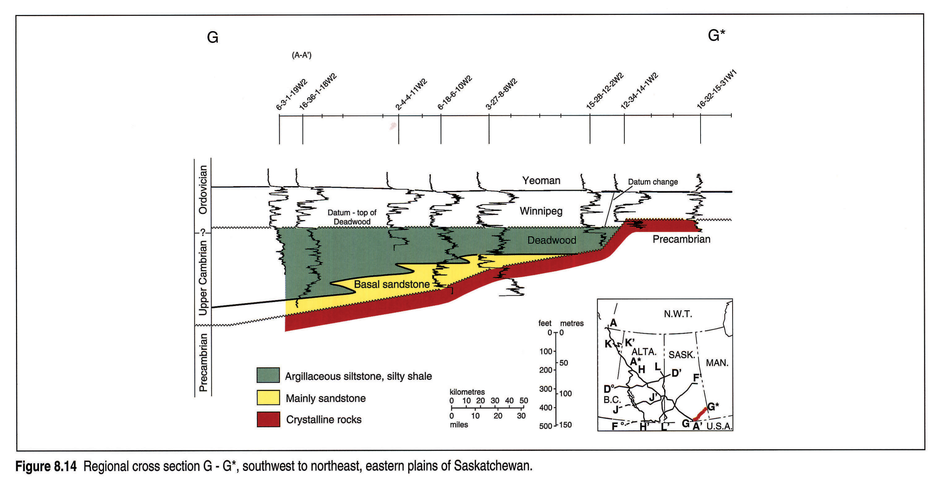
Section G - G*
The G - G* section (Fig. 8.14) crosses southern Saskatchewan beyond the eastern limit of the Earlie Formation. The Deadwood Formation consists of argillaceous sandstones overlying the Basal sandstone unit. The overlying Middle Ordovician Winnipeg Formation overlaps the Deadwood and lies directly on crystalline Precambrian.
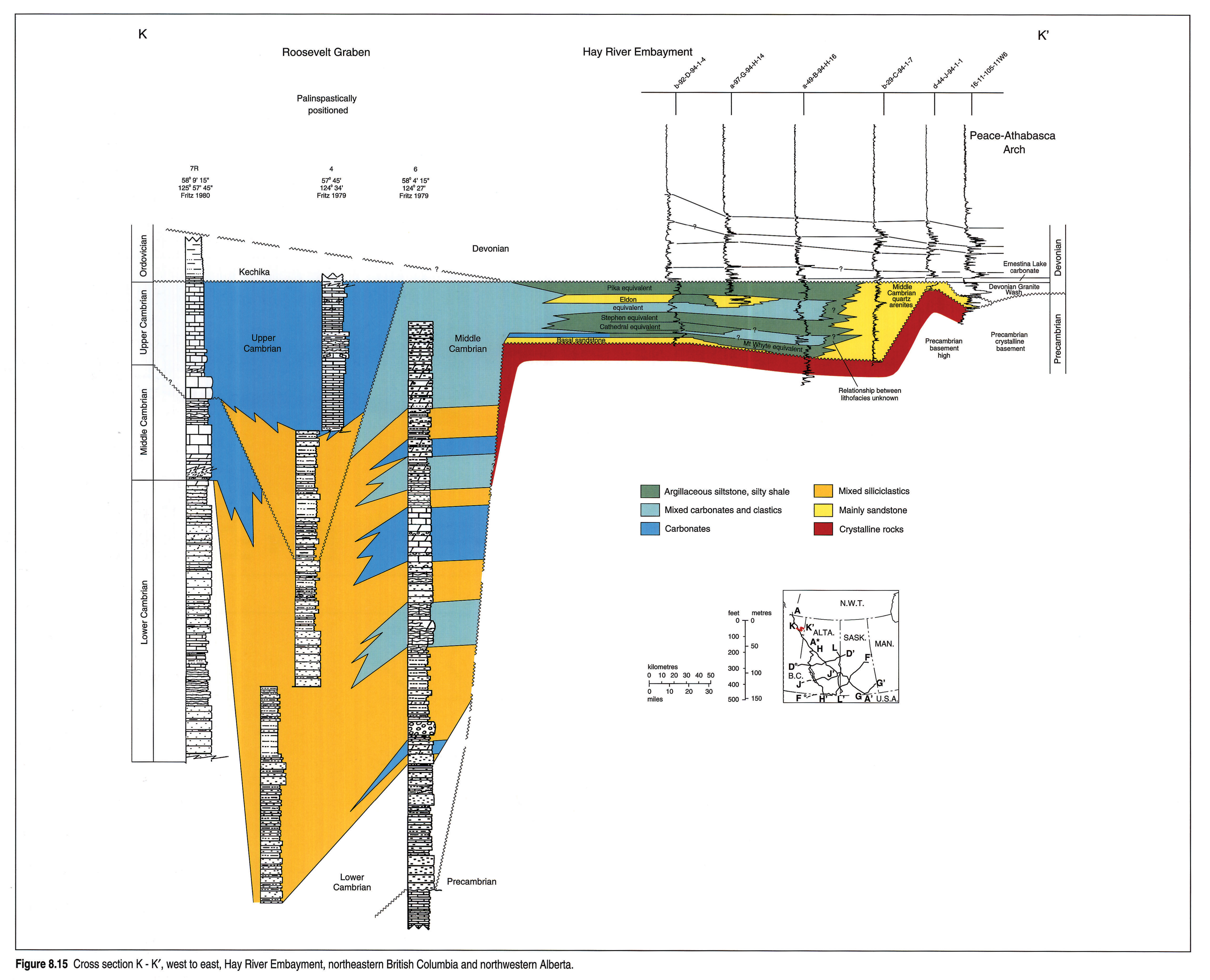
Section K - K'
Section K - K' (Fig. 8.15) extends from the Roosevelt Graben to the Hay River Embayment of northeastern British Columbia. There are few deep wells, and the section zigzags through the area. The datum for the section is the Devonian Ernestina Lake carbonate in the east and the top of the Cambrian in the west. Some challenge these correlations and interpret a significant amount of pre-Ernestina Lake Devonian sediments to be present. This presentation follows Pugh (1971) in the east and Fritz (1972, 1980) in the west.
The section shows dramatic west-to-east change in lithofacies and thickness. In the Roosevelt Graben in the west, the sequence is more than 1000 m thick and is composed of thick, quartz-rich clastics overlain by limestones and clastics of Early Cambrian to Late Cambrian age (see Fritz, 1974, 1980).
On the platform (Hay River Embayment), the Middle Cambrian rests unconformably on Precambrian basement and comprises a mixed siliciclastic-carbonate lithofacies assemblage. Carbonates interpreted as equivalent to the Eldon and Cathedral formations occur in a-49-B/94-H-16. Farther east the whole Middle Cambrian section passes into a siliciclastic assemblage rich in quartz sand, within which correlation of the western formations is not possible. The easternmost two wells show drastic thinning of the Middle Cambrian arenites onto a local Precambrian(?) high. The distinction between Cambrian clastics and Devonian Granite Wash is not clear at the eastern end of the section.
Reference Logs
Three reference wells illustrate the log response of the Middle Cambrian to Lower Ordovician formations of the WCSB.
Aquitaine - Mobil Cutoff 5-7 (5-7-35-11W5) (Fig. 8.16) penetrates the Brazeau Thrust Sheet in the central foothills, and is typical of foothills and western plains wells (Fig. 8.12). The Cambrian lies unconformably beneath the Devonian Elk Point Group and is faulted out in the lower part of the Cathedral Formation at 2952 m. All measurements are log depths below K.B. The section is dominated by thick-bedded carbonates.
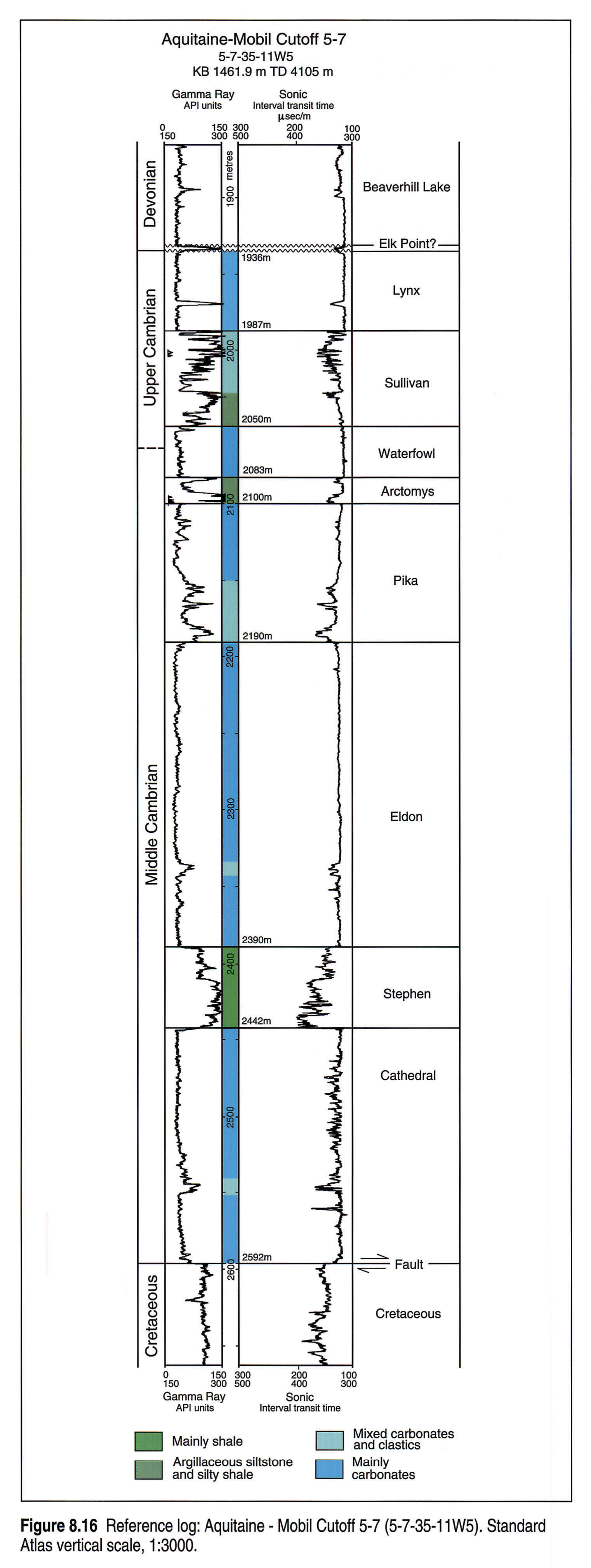
The Lynx lies immediately beneath the radioactive shale of the Devonian Elk Point(?) at 1936 m. The lower part of the Lynx is shaly, possibly including a finger of Sullivan-like clastics. Sullivan shale is encountered at 1987 m, identified by a gamma-ray high and sonic low. The Waterfowl carbonates are quite clean and characterized by a low gamma-ray response beginning at 2050 m. The Arctomys at 2083 m has a very strong gamma-ray response. The top of the Pika is picked at the base of the shales of the Arctomys where the gamma-ray curve abruptly diminishes at 2100 m.
The lower part of the Pika is shaly and its contact with the clean carbonates of the Eldon is picked at 2190 m where gamma-ray response is sharply reduced. The base of the Eldon is at the top of the mildly radioactive shales of the Stephen, at 2390 m. The Stephen/Cathedral boundary is sharp, picked at 2442 m where the gamma-ray response is sharply diminished and the velocity increases.
Pan-Canadian Petroleum Entice 9-6 (9-6-28-23W4) (Fig. 8.17) is half way between the foothills and eastern plains (Fig. 8.10) and is representative of the central Alberta part of the basin. The Upper Cambrian-Lower Ordovician Deadwood Formation is overlain by Devonian Elk Point, and the Middle Cambrian lies unconformably on Precambrian crystalline rocks.
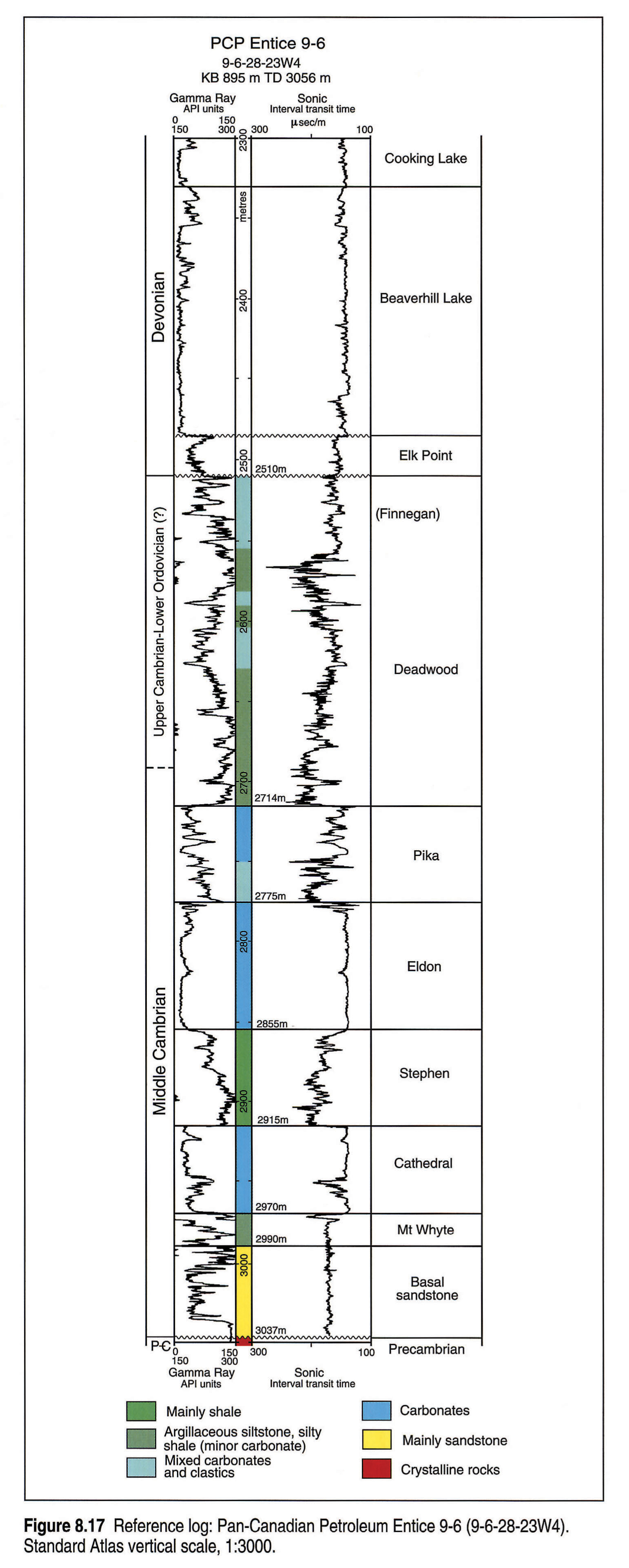
The Pika to Mount Whyte Middle Cambrian interval contains the same formations as in the Cutoff 5-7 well, but the entire sequence is much thinner and the carbonate formations are less than half as thick as those in the foothills. Upper Cambrian rocks above the Pika are markedly different in these two wells, reflecting the facies change from the carbonate formations of the foothills to the fine-grained clastics of the Deadwood Formation. Thickness of the Deadwood interval in the Entice well is greater than the post-Pika interval in the Cutoff well. The upper part of the Upper Cambrian in the Cutoff well was removed by early Devonian erosion on the West Alberta Arch.
An increase in radioactivity at 2510 m marks the Middle Devonian - Deadwood contact. Uppermost Cambrian strata are in the transition facies between the Lynx carbonate-rich section to the west and the fine-grained clastics of the Deadwood Formation to the east. The base-Deadwood, top-Pika boundary is picked at 2714 m, at a sharp gamma-ray decrease and velocity increase. The base of the Pika is quite shaly and the top of the Eldon is a slightly argillaceous carbonate. The contact is picked at 2775 m, at a sharp decrease in radioactivity response. The base-Eldon, top-Stephen is at 2855 m, at the top of a strong gamma-ray response. The top of the Cathedral is marked by a sharp decrease in radioactivity and an increase in velocity at 2915 m. The Mount Whyte is picked at 2970 m where the gamma-ray response is very high. The Basal sandstone is gradational with the Mount Whyte and is picked at 2990 m, where there is a small but perceptible decrease in radioactivity. Precambrian strata are intersected at 3037 m, based on lithological samples and a sharp gamma-ray increase.
British American et al. Canmer 6-9 (6-9-31-1W4) (Fig. 8.18), near the Alberta-Saskatchewan boundary, is typical of this part of the basin. The well is included on Section J - J' (Fig. 8.10). The Cambrian - Lower Ordovician interval is overlain by Upper Ordovician Red River Formation (Yeoman) and lies unconformably on Precambrian crystalline basement at 7167 ft.
The Middle Cambrian Pika Marker is carried from the west and separates the Upper Cambrian Deadwood Formation from the Middle Cambrian Earlie Formation. The Middle Cambrian carbonate formations in the west are here represented by clastics and the entire interval is thinned.
The Deadwood Formation is thick and typical of much of the area. Its top is placed at a sharp gamma-ray increase and velocity decrease at 5604 ft. The Pika Marker is picked on a sharp gamma-ray "notch" at 6520 ft. It is established by correlations with adjacent wells that contain a better defined Pika.
The top of the Basal sandstone unit is picked at a decrease of radioactivity at 6518 ft. Although 100 m thick in the reference well, the Basal sandstone thickness is quite variable in the area. A tongue of Mount Whyte shaly strata (moderately radioactive) occurs below 6932 ft.
Thickness and Lithology
Formation depths and thicknesses are based on the Atlas database. Wells used in the cross sections and those showing obvious thickness and structural anomalies have been individually confirmed or corrected. All other wells in the file have been statistically screened and have been accepted as correct although some minor errors probably occur. Lithological information is derived from Canadian Stratigraphic Service's Lithodata file.
Isopach Maps
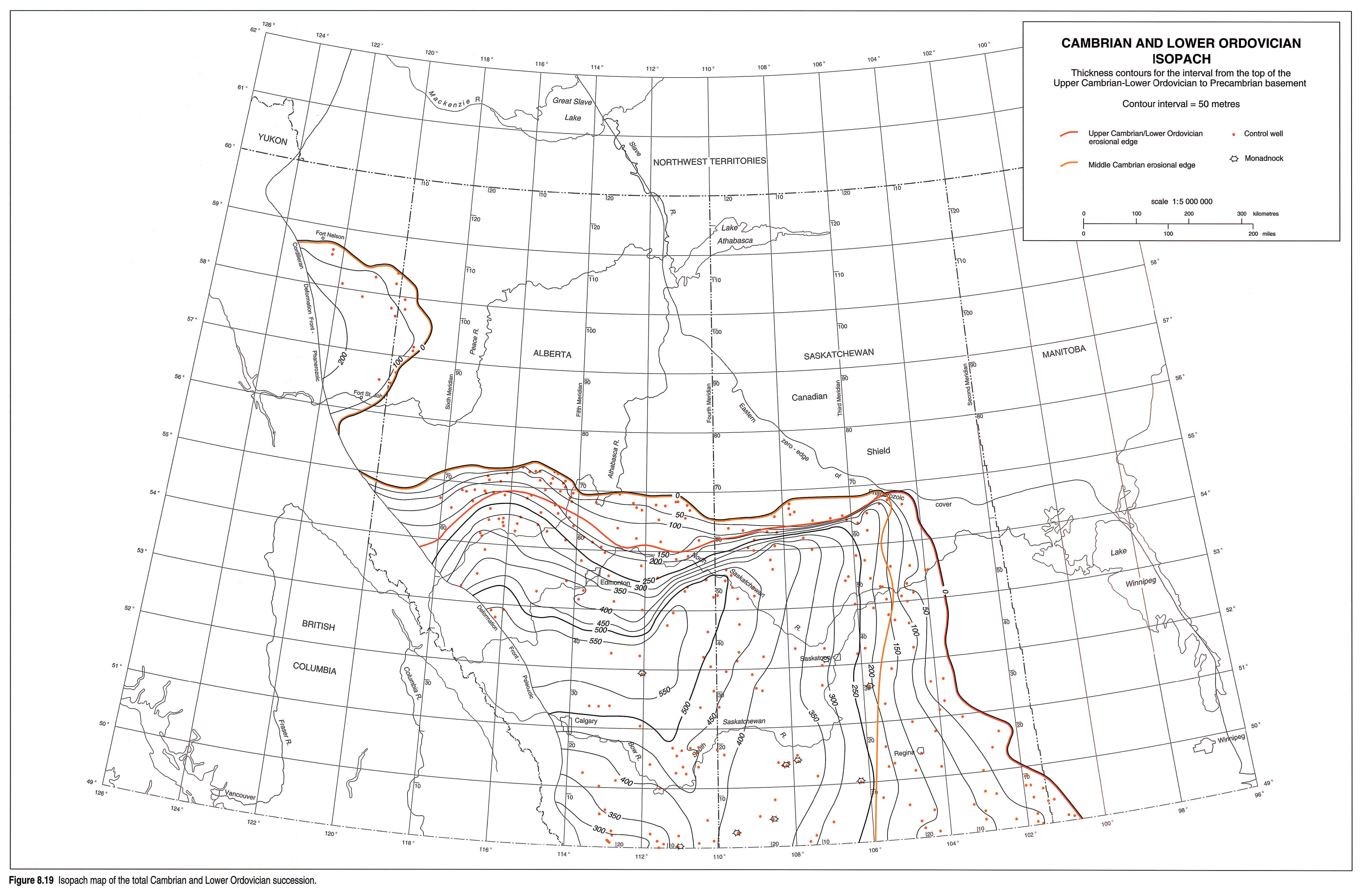
Lower Ordovician to Precambrian Isopach Map
This gross-interval isopach map (Fig. 8.19) represents the body of rock between a deeply eroded surface above and an irregular to rugged Precambrian topography below. Errors in the map very likely occur in the northwest where Devonian carbonates are difficult to separate from Upper Cambrian carbonates, and around the Peace-Athabasca Arch, where the Cambrian and Devonian clastics are very similar.
The map extends westward to the edge of the foothills. Many foothills wells have Cambrian strata but are faulted out above the base of the Cambrian. No thrusted Precambrian crystalline rock has ever been drilled in Alberta.
The map is not particularly useful in understanding the sedimentary history of the internal Cambrian interval because it is bounded by two major unconformities. It is nonetheless helpful in revealing errors in the Middle Cambrian and Lower Ordovician/Upper Cambrian isopachs, caused by Pika Marker miscorrelations.
Middle Cambrian Isopach Map
The map (Fig. 8.20) encompasses sediments bounded by the flat-lying Pika Formation or Pika Marker above and the topographically variable Precambrian crystalline basement below. Included in the interval are the carbonate-rich Mount Whyte to Pika succession in the west and the Basal sandstone unit and overlying Earlie Formation in the east. The Pika datum is used to separate the Middle and Upper Cambrian series on the maps, and is generally reliable; however, a few isopach anomalies may be the result of questionable Pika identifications that were not picked up during the screening process. The Pika is difficult to recognize in the northeastern part of the WCSB.
The isopach illustrates the eastern thinning and pinch-out by onlap on the Precambrian basement, a general thickening toward the west, and truncation near 55°N where the Middle Cambrian is eroded at the sub-Devonian unconformity. In southern Alberta and southern Saskatchewan, the Middle Cambrian thins by onlap onto local highs (monadnocks) in the Precambrian basement. Middle Cambrian strata are also thin along an ill-defined north-south trend just east of Edmonton, in the vicinity of 112°W.
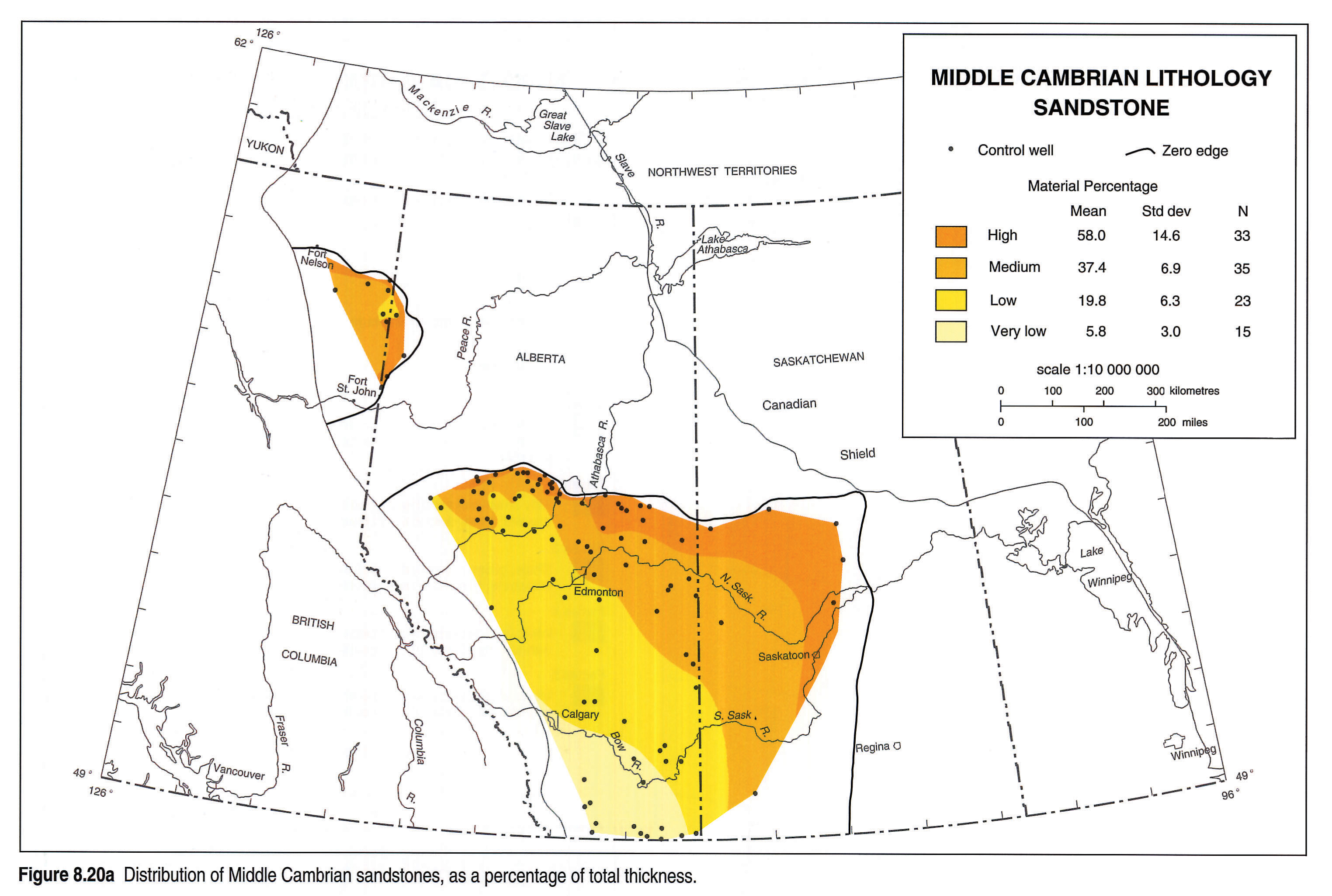
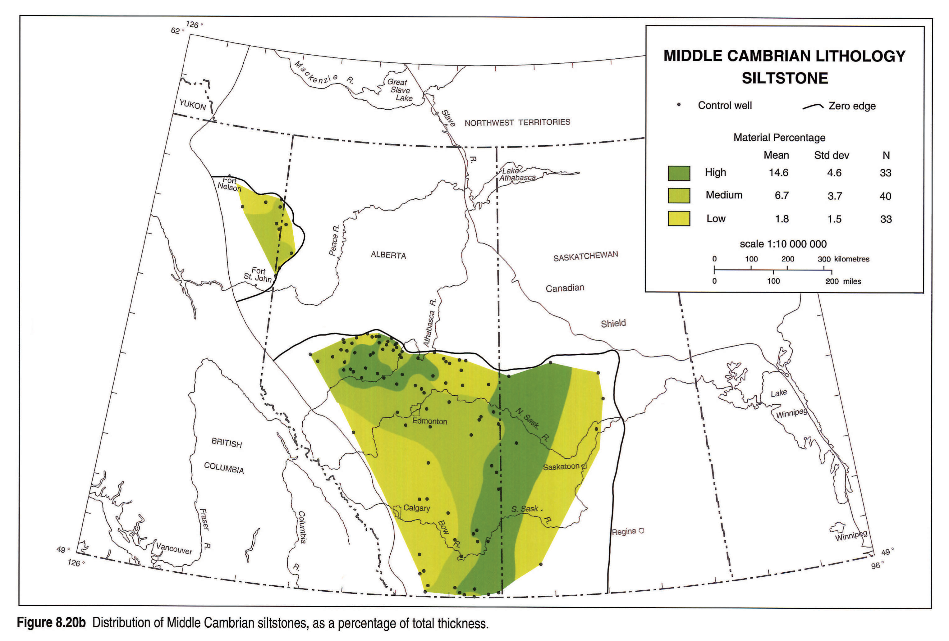
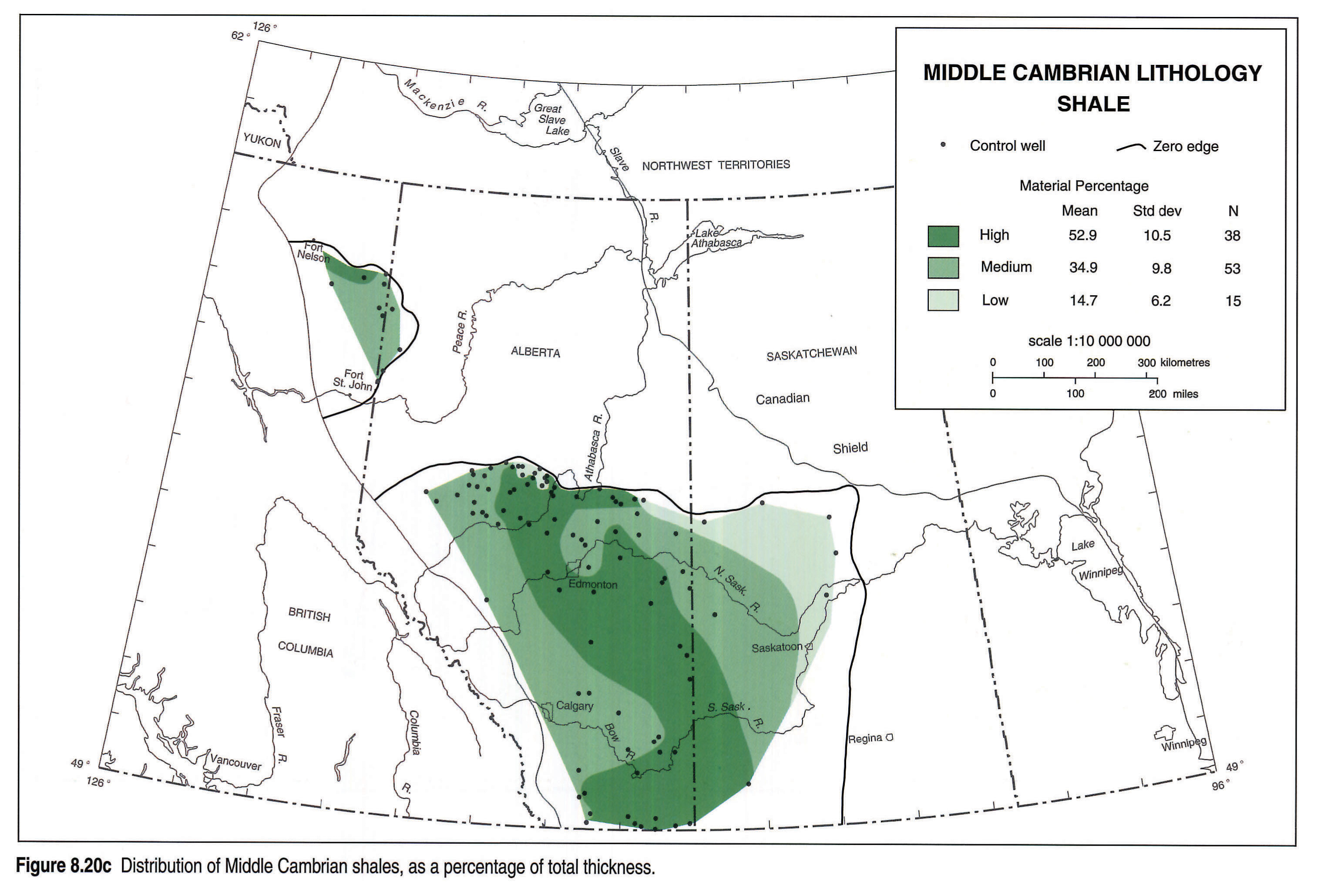
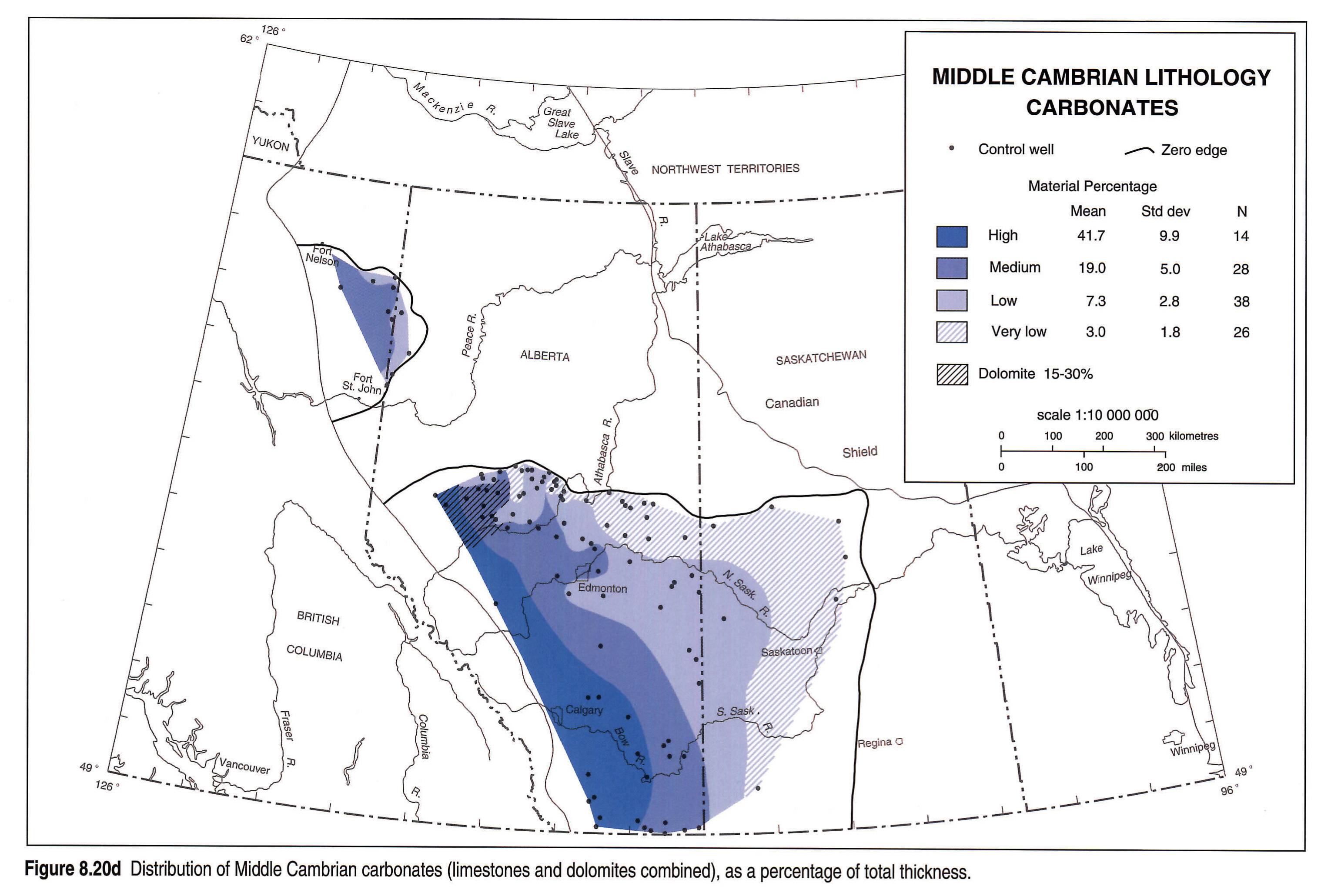
Lithofacies patterns, derived from Canstrat data, illustrate the westward increase in carbonates. Variations in the distribution of individual lithological components are shown in the auxilliary maps (Figs. 8.20a, 8.20b, 8.20c and 8.20d).
A small remnant of Middle Cambrian is preserved in the Hay River Embayment, where it laps onto the Precambrian to the north, south, and east and is unconformably overlain by the Devonian. The embayment is interpreted as continuing to the west, into the mountains of northeastern British Columbia and opening into the Roosevelt Graben.
Middle Cambrian thicknesses from palinspastically restored foothills wells and mountain outcrops control the western contours, in the Cordillera.
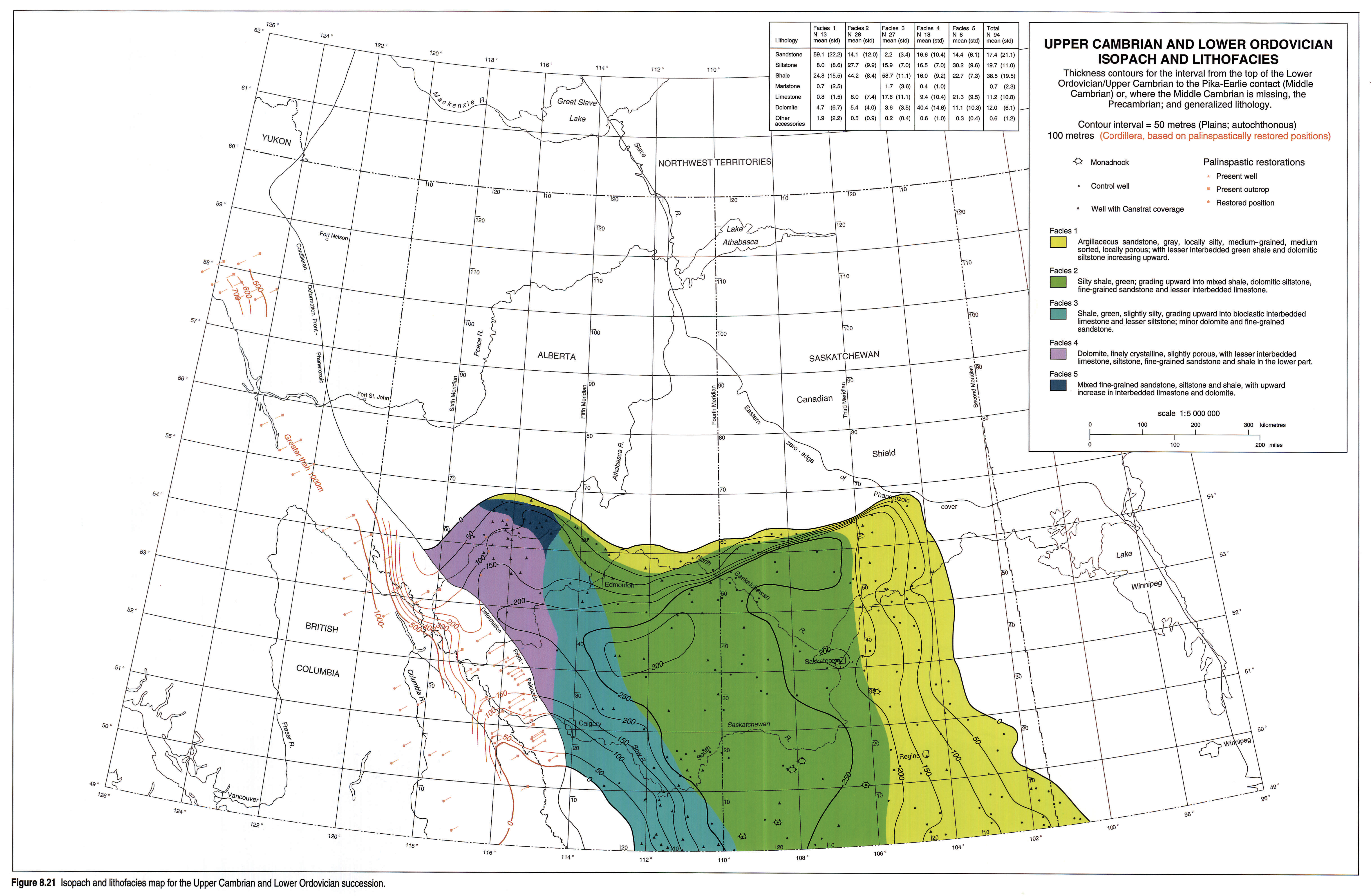
Lower Ordovician and Upper Cambrian Isopach Map
In the west the isopach map (Fig. 8.21) generally includes carbonate-rich formations of latest Middle Cambrian to Late Cambrian age. The base of the interval is the top of the Pika Formation. The upper boundary is drawn at the base of the concordantly overlying Middle and Upper Ordovician, or at the base of the unconformably overlying Devonian. Cordilleran contours are based on the palinspastically restored positions of wells and outcrop sections in the foothills and Rockies.
To the east, the interval comprises the Late Cambrian to Early Ordovician Deadwood Formation. Where the Pika (or Pika Marker) is not recognized, the Deadwood lies directly on the Earlie Formation.
The sub-Devonian unconformity cuts down sharply into the Upper Cambrian, especially along the Meadow Lake Escarpment, the Peace-Athabasca Arch and along the West Alberta Arch. The Upper Cambrian has been completely removed over the West Alberta Arch, southwest of Calgary.
Lithofacies patterns reflect, again, the dominance of clastics in the east and the increase in carbonates toward the west (Fig. 8.21). Details of variations in specific lithologies are shown in the auxilliary maps (Figs. 8.21a, 8.21b, 8.21c and 8.21d).
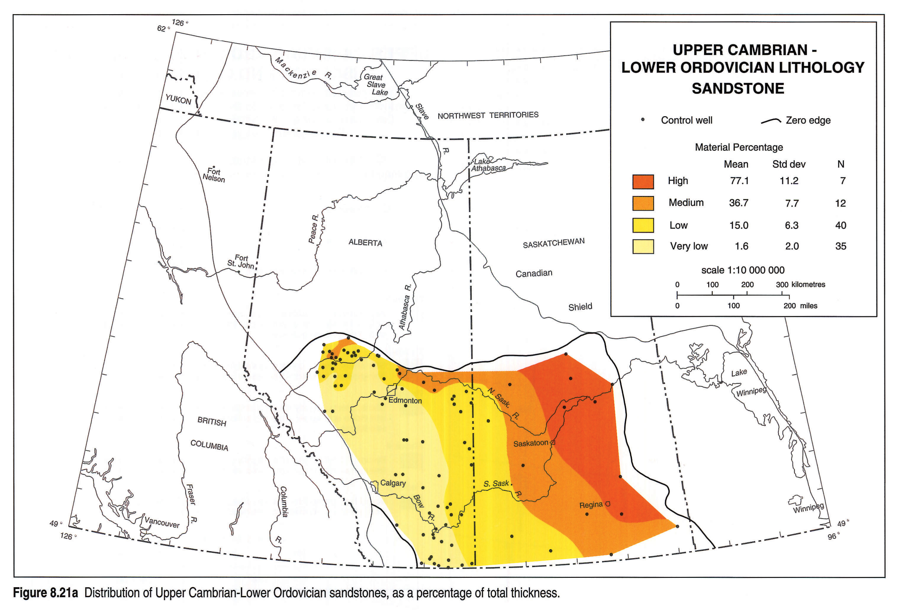
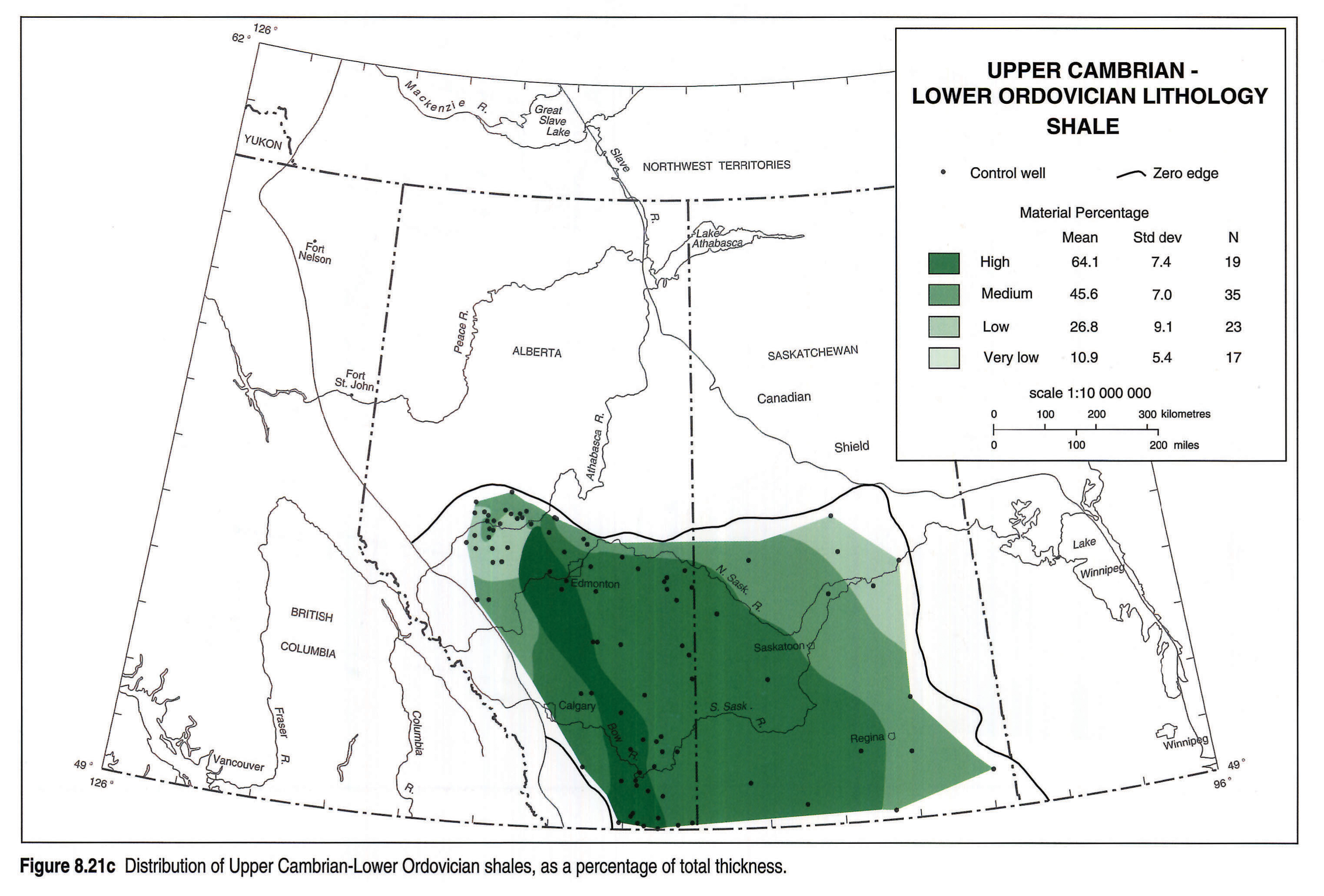
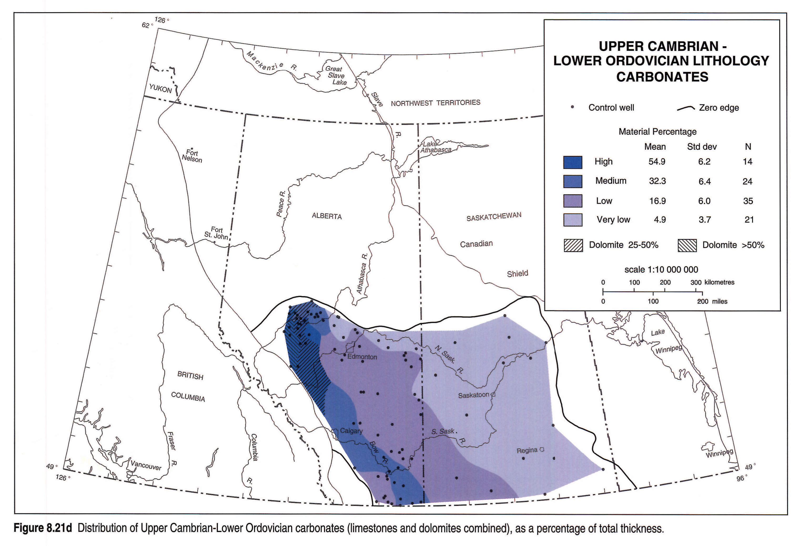
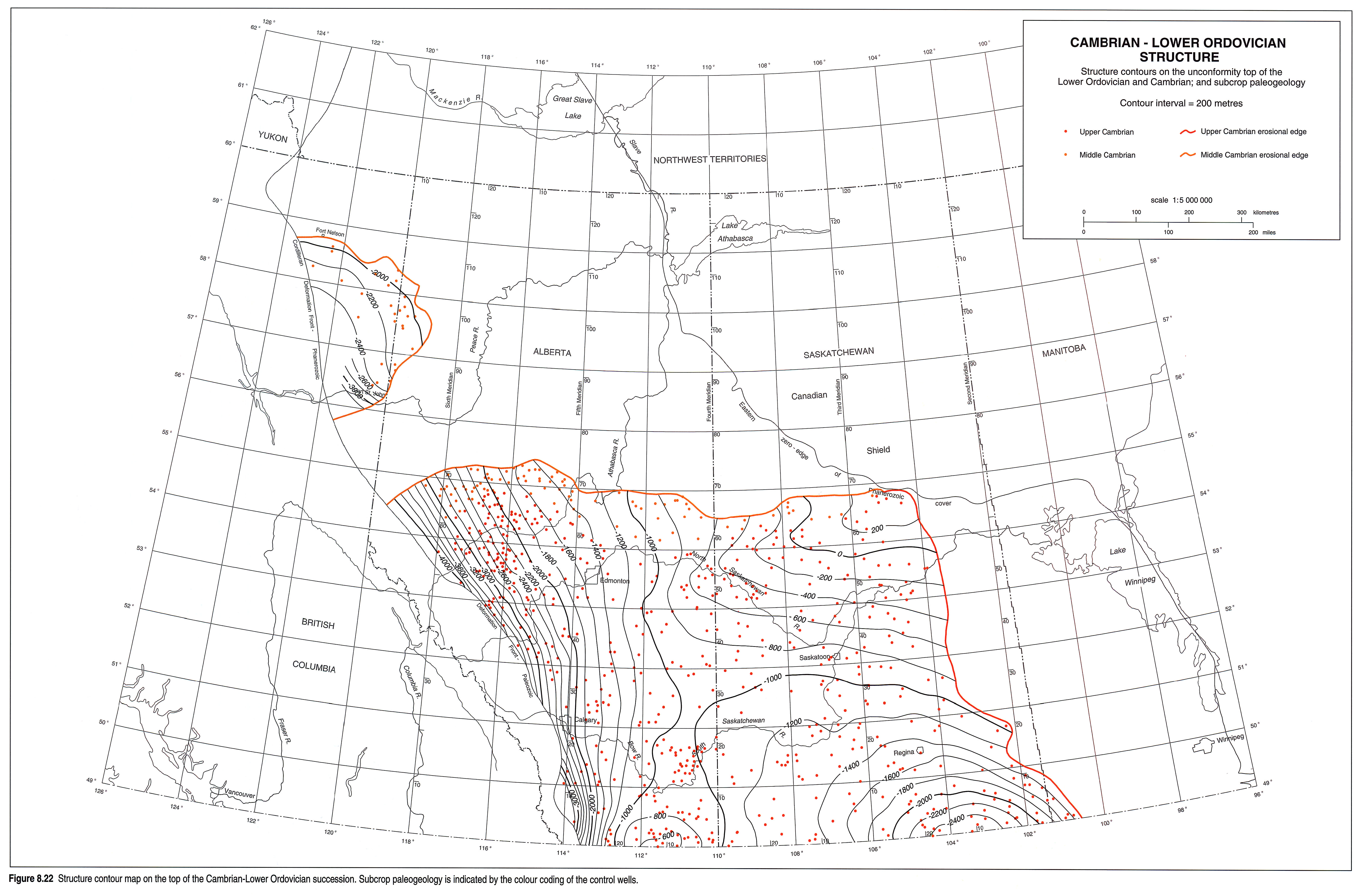
Structure
The top-Cambrian/Lower Ordovician structure map (Fig. 8.22) reflects sub-Devonian erosion and local and regional tectonics. The structural surface is carried into the foothills or mountains and control is limited to wells with autochthonous Cambrian strata.
The top of the Cambrian/Lower Ordovician dips steeply to the southwest under a westward-thickening wedge of younger sediments. Superimposed on this dominantly west-dipping surface are a number of structural and topographic elements. The surface has been shaped largely by sub-Devonian erosion, although pre-Middle Ordovician truncation has affected the surface to a small extent in eastern Alberta and southern Saskatchewan.
Later tectonic features such as the Peace-Athabasca Arch and the West Alberta Arch strongly influenced the depth of the downcutting into the stratigraphic interval. The present-day Cambrian is depressed in the Williston Basin, uplifted on the Sweetgrass Arch and steeply monoclinal under the foothills of western Alberta.
A trend of Middle Cambrian thinning striking vaguely north-south near 112° may have been caused by a positive structure that developed in pre-Late Cambrian time and persisted through subsequent erosion, although it is more likely that the thinning is caused by underlying Precambrian topography.
Acknowledgements
We wish to especially acknowledge the support of Shell Canada Limited and Saskatchewan Energy and Mines and their drafting departments for preparing the original cross sections and other illustrations. Also, we had access to their log files and extensive libraries. Shell Canada provided us with palinspastic restorations of foothills and mountain control points. Canadian Hunter Exploration Ltd. drafted illustrations used in the preliminary presentation of the material in 1990.
Authors of the Lower Cambrian, Ordovician and Silurian and Middle Devonian chapters of this volume have been very free with their help and advice. We made full use of J.D. Aitken's published works but also had access to much of his unpublished material and benefited from a number of personal discussions. D.E. Glass of Unocal Canada Limited assisted in correlations of the subsurface Cambrian. Special thanks are extended to Margaret Jessop for typing and proofing.
References
- Aitken, J.D. 1966. Middle Cambrian to Middle Ordovician cyclic sedimentation, southern Rocky Mountains of Alberta. Bulletin of Canadian Petroleum Geology, v. 14, p. 405-441.
- Aitken, J.D. 1968. Cambrian sections in the easternmost southern Rocky Mountains and the adjacent subsurface, Alberta. Geological Survey of Canada, Paper 66-23.
- Aitken, J.D. 1971. Control of lower Paleozoic sedimentary facies by the Kicking Horse Rim, southern Rocky Mountains, Canada. Bulletin of Canadian Petroleum Geology, v. 19, p. 557-569.
- Aitken, J.D. 1978. Revised models for depositional grand cycles, Cambrian of Western Canada. Bulletin of Canadian Petroleum Geology, v. 26, p. 515-542.
- Aitken, J.D. 1981. Generalizations about grand cycles. In: Short Papers for the Second International Symposium on the Cambrian System. M.E. Taylor (ed.). United States Geological Survey, Open File Report 81-743, p. 8-14.
- Aitken, J.D. 1989a. Birth, growth and death of the Middle Cambrian Cathedral carbonate lithosome, Southern Rocky Mountains. Bulletin of Canadian Petroleum Geology, v. 37, p. 316-333.
- Aitken, J.D. 1989b. The Sauk sequence - Cambrian to Lower Ordovician miogeosyncline and platforms. In: Western Canada Sedimentary Basin, a Case History. B.D. Ricketts (ed.). Canadian Society of Petroleum Geologists.
- Aitken, J.D. in press a. Middle Cambrian stratigraphy of the southern Rocky Mountains, Canada. Geological Survey of Canada, Bulletin.
- Aitken, J.D. in press b. Chapter 4B Sauk Sequence. In: Sedimentary cover of the North American Craton - Canada, D.F. Stott and J.D. Aitken (eds.). Geological Survey of Canada, Geology of Canada.
- Aitken, J.D., Fritz, W.H., and Norford, B.S. 1972. Cambrian and Ordovician biostratigraphy of the southern Canadian Rocky Mountains. International Geological Congress, Guidebook XXIV A19.
- Aitken, J.D. and Greggs, R.G. 1967. Upper Cambrian formations, southern Rocky Mountains of Alberta, an interim report. Geological Survey of Canada, Paper 66-49.
- Aitken, J.D. and Norford, B.S. 1967. Lower Ordovician Survey Peak and Outram formations, southern Rocky Mountains of Alberta. Bulletin of Canadian Petroleum Geology, v. 15, p. 150-207.
- Allan, J.A. 1914a. Rocky Mountains section between Banff, Alberta and Golden, British Columbia, along the Canadian Pacific Railway. Geological Survey of Canada, Summary Report 1912, p. 165-176.
- Allan, J.A. 1914b. Geology of Field map-area, British Columbia and Alberta, Canada. Geological Survey of Canada, Memoir 55.
- Burling, L.D. 1914. Early Cambrian stratigraphy in the North American Cordillera, with discussion of Albertella and related faunas. Geological Survey of Canada, Museum Bulletin no.2, p. 93-129.
- Burling, L.D. 1955. Annotated index of the Cambro-Ordovician of the Jasper Park and Mount Robson region. Alberta Society of Petroleum Geologists Guidebook, 5th Annual Field Conference, p. 15-51.
- Carlson, C.G. 1960. Stratigraphy of the Winnipeg and Deadwood formations in North Dakota. North Dakota Geological Survey, Bulletin 35, p. 149.
- Conway Morris, S. and Whittington, H.B. 1985. The Burgess Shale in Yoho National Park. Geological Survey of Canada, Miscellaneous Report 43.
- Cook, D.G. 1975. Structural style influenced by lithofacies, Rocky Mountains Main Ranges, Alberta and British Columbia. Geological Survey of Canada, Bulletin 233.
- Dean, W.T. 1990. Trilobites from the Survey Peak, Outram and Skoki formations (Upper Cambrian - Lower Ordovician) at Wilcox Pass, Jasper National Park, Alberta. Geological Survey of Canada, Bulletin 389.
- Deiss, C.F. 1940. Lower and Middle Cambrian stratigraphy of southwestern Alberta and southeastern British Columbia. Geological Society of America, Bulletin, v. 51, p. 731-794.
- Douglas, R.C. (ed.) 1970. Geology and economic minerals of Canada. Geological Survey of Canada, Economic Geology Report (5th ed.).
- Fritz, W.H. 1972. Cambrian biostratigraphy, western Rocky Mountains, British Columbia. In: Report of Activities, Part A, Geological Survey of Canada, Paper 72-1A, p. 209-211.
- Fritz, W.H. 1978. Upper (carbonate) part of Atan Group, Lower Cambrian, north-central British Columbia. In: Current Research, Part A, Geological Survey of Canada, Paper 78-1A, p. 7-16.
- Fritz, W.H. 1979. Cambrian stratigraphy in the northern Rocky Mountains, British Columbia. In: Current Research, Part B, Geological Survey of Canada, Paper 79-1B, p. 99-109.
- Fritz, W.H. 1980. Two Cambrian stratigraphic cross-sections near Gataga River, Northern Rocky Mountains, British Columbia. In: Current Research, Part C, Geological Survey of Canada, Paper 80-1C, p. 113-119.
- Fritz, W.H. and Mountjoy, E.W. 1975. Lower and early Middle Cambrian formations near Mount Robson, British Columbia and Alberta. Canadian Journal of Earth Sciences, v. 12, p. 119-131.
- Fuller, J.G.C.M. and Porter, J.W. 1962. Cambrian, Ordovician and Silurian formations of the northern Great Plains, and their regional connections. Journal of Alberta Society of Petroleum Geologists, v. 10, p. 455-485.